The item illustrated and described below is sold, but we
have another example in stock. To view the example which
is currently being offered for sale, click the
"View Details" button below.


|
||

|

|
|

|
Stock# m0021
Description
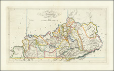
Exceptional example of this map of Kentucky from the 1814 edtion of Matthew Carey's General Atlas, the first appearance of hand coloring in an American Atlas.
One of the earliest obtainable maps of Kentucky to include counties, with still only a small number shown. Matthew Carey issued the first American published Atlas in 1795, which was subsequently updated in 1796, 1800 and again in 1814, with the 1814 being the first obtainable in original color. Nice wide margined example of this map, which rarely appears on the market.

![[Alabama, Mississippi, Arkansas, Louisiana and part of Tennessee and Western Florida] Amer. Sep. No. 56 Partie des États Unis](https://storage.googleapis.com/raremaps/img/small/93538.jpg)