The item illustrated and described below is sold, but we
have another example in stock. To view the example which
is currently being offered for sale, click the
"View Details" button below.


|
||

|

|
|

|
Stock# 9987
Description
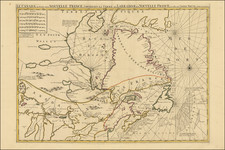
Scarce map of the northeastern portion of North America, based upon De L'Isle. Shows LaHontan's River system feeding the Mississippi and Missouri Rivers, an excellent depiction of the Great Lakes, the Upper Midwest and East Coast, along with excellent detail in Canada, the Maritimes, Hudson's Bay up to Greenland and the Arctic Circle. In the extreme West, near the Paese di Moozemblek, is a portage across the Rocky Mountains, connecting the Mississippi to what would likely have been the Pacific. Wonderful decorative title vignette, showing a mermaid bathing offshore, Indians hunting with bows, and working along the shore. A near fine wide margin example of this marvelous map, which is now rare on the market.