


|
||

|

|
|

|
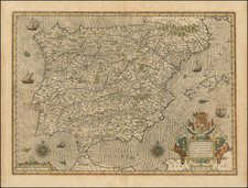
Spectacular map of Portugal, colored by regions and showing towns, fortified cities, rivers, mountains, islands, roads, etc. Includes a stunning large cartouche, with 4 coats of arms and many symbolic images, including an American Indian and a mermaid holding a sailing vessel aloft. Minor fold split, just enters printed image, but does not detract. Allard's maps are quite scarce. A rich full color example of this hard to find map. Tiny wormhole above the U in Regnorum is virtually invisible, except on close inspection. An excellent acquistion for collector's of maps of Portugal, the first example of this map that we have ever seen.
Carel (Carol) Allard (Allardt) (1648–1709) was an engraver and publisher based in Amsterdam. Part of a prominent family of Dutch mapmakers, publishers, and print sellers, his father was engraver and publisher Hugo Allard (1627–1684), who left his business to Carel upon his death. Carel published anything in demand, including maps, topography, ethnography, newsprints, and restrikes of old plates of artistic prints, many of which likely came from his father’s stock. In 1706, Carel gave his copperplates to his son Abraham Allard, before going bankrupt.
![Parte Septentrional do Reyno de Portugal... 1654 [with] Partie Meridional do Reyno de Portugal.... 1654](https://storage.googleapis.com/raremaps/img/small/50470.jpg)
