This item has been sold, but you can enter your email address to be notified if another example becomes available.


|
||

|

|
|

|
Stock# 9723
Description
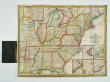
A gorgeous example of Flemming's 4 sheet map of the United States, exhibiting in fabulous detail.
The early US territorial borders, Indian Districts, Forts, early routes of the Transmississippi explorers and other details are shown.
Includes the various European colonies in Texas, many Indian tribes, forts, missions, roads, and other details. Too much good material to mention. Includes a very unusual tomahawk shaped Indian Territory and massive Minnesotah and Missouri Territories. Excellent topographical details, some real, some conjecture. Texas is a Republic. Not in Wheat. One of the best large format maps of the Unitd States during the period. Shows rivers from the Pacific to the two Salt Lakes, one of which is mythical.

![[French America and the Triangular Trade] L'Amérique Françoise Où son Décrites La France Nouvelle, La France Insulaire, La France Equinoctiale, et autre pais Par P. Du Val d'Abbeville Geographe du Roy . . .](https://storage.googleapis.com/raremaps/img/small/91968.jpg)