
This item has been sold, but you can enter your email address to be notified if another example becomes available.


|
||

|

|
|

|
Stock# 9635
Description
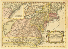
Gorgeous map of Boston, hand colored by wards. From the true first edition of Gray's Atlas. Extends to Charlestwon, Eastg Boston, South Boston, Roxbury and Somerville. Shows streets, roads, rail lines, buildings, parks, wharfs, bridges, etc. A fine map of the city.
O.W. Gray Biography
O. W. Gray was a publishing firm based in Philadelphia. Later, they published as O. W. Gray & Son. They published atlases in the late nineteenth century. Gray's National Atlas was one of the most successful commercial ventures of the 1870s and one of the last to employ hand coloring on maps.


![(Colonial New England Ironworks) [Early 19th-century manuscript copy of 1674 New England land transaction involving John Gifford; mention of early ironworks in Massachusetts]](https://storage.googleapis.com/raremaps/img/small/93113.jpg)