This item has been sold, but you can enter your email address to be notified if another example becomes available.


|
||

|

|
|

|
Stock# 9631
Description
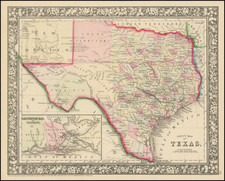
Striking decorative map of Texas, hand colored by counties. From the true first edition of Gray's Atlas. Includes inset of Galveston and Sabine Lake. Shows towns, roads, railroads, mountains, rivers, Indian information, forts, etc. Texas is still dominated by the large western counties of Bexar, Young Territory, Pecos, El Paso and Presidio. A fine example.
O.W. Gray Biography
O. W. Gray was a publishing firm based in Philadelphia. Later, they published as O. W. Gray & Son. They published atlases in the late nineteenth century. Gray's National Atlas was one of the most successful commercial ventures of the 1870s and one of the last to employ hand coloring on maps.