


|
||

|

|
|

|
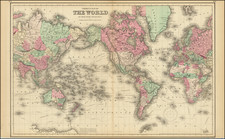
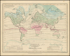
Colton's Map of the World on Mercator's Projection, published in New York in 1873, provides a captivating snapshot of the world during the late 19th century. The map is distinguished by its representation of various exploratory routes undertaken by renowned 18th- and 19th-century explorers like Cook, Furneaux, and Vancouver. Additionally, it displays geopolitical borders that were in flux during the period, offering a comprehensive view of the world's political landscape.
As an era of exploration, the 18th and 19th centuries saw numerous voyages, the routes of which this map diligently traces. From Cook's iconic voyages that revolutionized Western understanding of the Pacific to the journeys of the USS Vincennes and La Perouse, these explorations played a critical role in shaping the geographic and scientific knowledge of the time.
The map's color-coding by country and region provides a clear visualization of the world's geopolitical divisions. While some borders mirror today's nations, others denote political realities that have since changed, underlining the continual transformation of global politics and territorial sovereignty.
Notably, the map includes preliminary signs of the Antarctic Coast, signaling the expansion of geographic knowledge towards the world's extremities. While the world's shape on the map may be close to today's understanding, this feature highlights the ongoing exploration and discovery that characterized the period.
G. W. & C. B. Colton was a prominent family firm of mapmakers who were leaders in the American map trade in the nineteenth century. The business was founded by Joseph Hutchins Colton (1800-1893) who bought copyrights to existing maps and oversaw their production. By the 1850s, their output had expanded to include original maps, guidebooks, atlases, and railroad maps. Joseph was succeeded by his sons, George Woolworth (1827-1901) and Charles B. Colton (1831-1916). The firm was renamed G. W. & C. B. Colton as a result. George is thought responsible for their best-known work, the General Atlas, originally published under that title in 1857. In 1898, the brothers merged their business and the firm became Colton, Ohman, & Co., which operated until 1901, when August R. Ohman took on the business alone and dropped the Colton name.
![Tabula Geographica Hemisphaerii Borealis ad emenatiora quae adhuc prodieruntexampla jusqu Acad. Reg. Scient. et Eleg. Litt. Boruss. descripta [with:] Tabula Geographica Hemisphaerii Australis...](https://storage.googleapis.com/raremaps/img/small/81806.jpg)