
The item illustrated and described below is sold, but we
have another example in stock. To view the example which
is currently being offered for sale, click the
"View Details" button below.
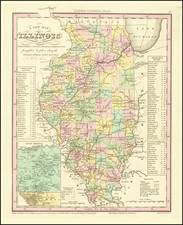
1836 Henry Schenk Tanner
$ 195.00


|
||

|

|
|

|
Stock# 9460
Description
Marvelous example of Tanner's map of Illinois, hand colored by counties.
Shows canals, railroads, towns, roads, distances, and tables with steam boat routes and distances. The county configuations are largely complete. Inset of the Lead Region of Wisconsin and Northwestern Illinois are shown in a large inset.
Tanner's New Universal Atlas became the standard work in the Industry until Tanner sold the rights to the atlas in 1846 to SA Mitchell. The early editions are well regarded for the high quality paper and fine engraving, comparable to the American Atlas. Tanner's Universal Atlas is now rare on the market and the separate maps are now increasingly difficult to obtain.

![Carte De La Louisiane Et Du Cours Du Mississipi . . . Juin 1718 [1st State!]](https://storage.googleapis.com/raremaps/img/small/59797.jpg)
![[French & Indian War] Carte Des Possessions Francoises et Angloises dans le Canada et Partie de la Louisiane . . . 1756](https://storage.googleapis.com/raremaps/img/small/94026.jpg)
