![[British Colonies in America] Carte Qui Contient Une Description Des Iles & Terres Que Les Anglois . . .[maps of Chesapeake, Carolinas, New England, Bermuda, Gulf Coast, Jamaica, Barbadoes & Canada] By Henri Chatelain](https://storage.googleapis.com/raremaps/img/small/61480.jpg)


|
||

|

|
|

|
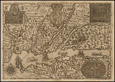
Highly sought after group of maps from Chatelain's 7 Volume Atlas Historique. Includes 8 maps, each of which would be highly coveted as a separate map. The maps include 1) a map of the Carolinas, 2) a map of the Chesapeake, 3) Canada and New England, 4) New England and New York, 5) Bermuda, 6) Barbados 7) Jamaica and 8) Florida, the Gulf Coast, Mexico, Central America and the Caribbean, along with substantial explanatory text. Each of the maps is extremely detailed, such that they would price out individually in the $250 to $500 range, if issued separately. This fact accounts for the remarkable scarcity of this map, which has not appeared in the Jolly Price Guide for a number of years. An essential map for Americana map collectors, representing a rare opportunity to buy such a fine compilation of early 18th Century regional American maps. Minor fold split, else a very attractive example.
Henri Abraham Chatelain (1684-1743) was a Huguenot pastor of Parisian origins. Chatelain proved a successful businessman, creating lucrative networks in London, The Hague, and then Amsterdam. He is most well known for the Atlas Historique, published in seven volumes between 1705 and 1720. This encyclopedic work was devoted to the history and genealogy of the continents, discussing such topics as geography, cosmography, topography, heraldry, and ethnography. Published thanks to a partnership between Henri, his father, Zacharie, and his younger brother, also Zacharie, the text was contributed to by Nicolas Gueudeville, a French geographer. The maps were by Henri, largely after the work of Guillaume Delisle, and they offered the general reader a window into the emerging world of the eighteenth century.
![[Martinique, Guadaloupe, Dominica and Marie Galante] . Suite des Isles Antilles 2. Partie](https://storage.googleapis.com/raremaps/img/small/81614.jpg)
![Carte Des Antilles Du Golfe Du Mexique et d'une partie des Etats voisons…1842 [Republic of Texas]](https://storage.googleapis.com/raremaps/img/small/98848.jpg)
![A New and Exact Map of the Dominions of the King of Great Britain on ye Continent of North America . . . [Beaver map]](https://storage.googleapis.com/raremaps/img/small/101277.jpg)
![Culiacanae, Americae Regionis, Descriptio [with] Hispaniolae, Cubae, Aliarumqe Insualrum Circumiacientium Delineatio](https://storage.googleapis.com/raremaps/img/small/86114.jpg)