


|
||

|

|
|

|
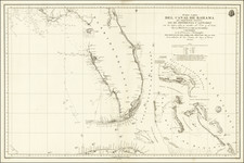
This 1893 "General Topographical Map. Sheet XII." from the War Department's Atlas to Accompany the Official Records of the Union and Confederate Armies, 1861-1865. offers an authoritative representation of the Gulf Coast, spanning from Biloxi to St. George's Sound, featuring Mobile Bay prominently. Published by the War Department in Washington, D.C., this resource serves as a valuable historical document.
The Civil War period was one of the most contentious and transformative eras in American history. During this time, the geographical landscape played a crucial role in strategizing military operations and understanding these topographies was critical for both the Union and Confederate armies. The map is thus not merely a geographical tool but an integral artifact that witnessed the nation's historical trajectory.
Mobile Bay, displayed prominently in the map, was the scene of a major naval conflict in August 1864, which effectively sealed off the last Confederate-controlled port on the Gulf of Mexico. It is worth noting that while the map was published in 1893, it depicts the coastal terrain during the Civil War years, providing a retrospective view of the region’s geography in the context of this significant event.


![[ Florida Native Americans ] Trophaeum & solennes ritus devictis hostibus. XVI. [Trophy and Solemn Rite after the Defeat of the Enemy.]](https://storage.googleapis.com/raremaps/img/small/98050.jpg)