


|
||

|

|
|

|
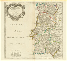
Portugal Agreeable to Modern History is an excellent map of Portugal by geographer Herman Moll published in 1729. Moll, based in London, was one of the most influential cartographers of his time.
The map provides a detailed representation of Portugal, distinguishing its territories based on ecclesiastical hierarchy - Archbishoprics and Bishoprics. It also marks the locations of the country's Universities.
It gives precise measurements of Portugal's geography, reporting that the country spans 27,851 square miles. It further provides the country's maximum length as 304 miles and its breadth as 133 miles. The number of inhabitants at the time is listed as one million.
The map also highlights Lisbon as the metropolis, describing it as a "fair, large, rich, and noble city," and acknowledging it as an Archbishopric and University city. Lisbon's position is detailed as being situated on the mouth of the Tajo or Tagus River.
A helpful addition is the information about the distances from Lisbon to other notable cities: Cadiz (215 miles), Madrid (275 miles), Porto (145 miles), and Compostella (265 miles).
This detailed map reflects Moll's commitment to precise, in-depth geographic representation, providing a rich snapshot of Portugal's geographical and cultural landscape in the early 18th century.
Herman Moll (c. 1654-1732) was one of the most important London mapmakers in the first half of the eighteenth century. Moll was probably born in Bremen, Germany, around 1654. He moved to London to escape the Scanian Wars. His earliest work was as an engraver for Moses Pitt on the production of the English Atlas, a failed work which landed Pitt in debtor's prison. Moll also engraved for Sir Jonas Moore, Grenville Collins, John Adair, and the Seller & Price firm. He published his first original maps in the early 1680s and had set up his own shop by the 1690s.
Moll's work quickly helped him become a member of a group which congregated at Jonathan's Coffee House at Number 20 Exchange Alley, Cornhill, where speculators met to trade stock. Moll's circle included the scientist Robert Hooke, the archaeologist William Stuckley, the authors Jonathan Swift and Daniel Defoe, and the intellectually-gifted pirates William Dampier, Woodes Rogers and William Hacke. From these contacts, Moll gained a great deal of privileged information that was included in his maps.
Over the course of his career, he published dozens of geographies, atlases, and histories, not to mention numerous sheet maps. His most famous works are Atlas Geographus, a monthly magazine that ran from 1708 to 1717, and The World Described (1715-54). He also frequently made maps for books, including those of Dampier’s publications and Swift’s Gulliver’s Travels. Moll died in 1732. It is likely that his plates passed to another contemporary, Thomas Bowles, after this death.
![[Spain & Portugal] Tabula Europae II](https://storage.googleapis.com/raremaps/img/small/89871.jpg)
![[Terceira Island] Tercera](https://storage.googleapis.com/raremaps/img/small/76123.jpg)
![[Portugal] Pascaarte vande Zeecusten van Portugal tusschen de Barlenges en de C. de S. Vincente geleghen, vertoonende nae't leven de ware geleghentheijt vande vermaerde Riviere van Lisbona . . .](https://storage.googleapis.com/raremaps/img/small/40065.jpg)