|
||

|

|
|

|
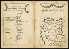
Authored by the renowned British cartographer, Herman Moll, and published in London in 1729, this attractive map encapsulates the geographical demarcations of the Iberian Peninsula during the 18th century. Serving as a testament to pre-Enlightenment cartography, the map captures the geopolitical landscape of the Spanish and Portuguese kingdoms, bringing to life an era marked by territorial expansion and exploration.
The representation of the Iberian Peninsula showcases the individual provinces depicted in varied outline colors, each indicative of the different kingdoms and principalities as understood in modern history. The map offers an intricate visualization of the regional topography, presenting a variety of natural and man-made features. Roads and towns punctuate the landscape, suggesting the infrastructure and settlement patterns of the time. The rendition of the water bodies, including rivers, bays, and islands, offers valuable information about the hydrographical attributes of the region.
Unfolding against the backdrop of the Age of Enlightenment, this map reflects the historical shifts of the early 18th century. The depiction of the Iberian Peninsula came during a period when Spain and Portugal were major global powers, their influences shaping Europe and the wider world. This map offers a visual narrative of their territorial boundaries during a period marked by political maneuvering, shifting alliances, and changing colonial territories.
The map, produced by Herman Moll, is a testament to his reputation for precision and attention to detail. A prominent figure in British cartography, Moll's work is known for its accurate geographical information and its aesthetically pleasing design. This map of Spain and Portugal is no exception, carrying the distinct style and quality of Moll's cartography and offering an engaging window into the historical geography of the Iberian Peninsula.
Herman Moll (c. 1654-1732) was one of the most important London mapmakers in the first half of the eighteenth century. Moll was probably born in Bremen, Germany, around 1654. He moved to London to escape the Scanian Wars. His earliest work was as an engraver for Moses Pitt on the production of the English Atlas, a failed work which landed Pitt in debtor's prison. Moll also engraved for Sir Jonas Moore, Grenville Collins, John Adair, and the Seller & Price firm. He published his first original maps in the early 1680s and had set up his own shop by the 1690s.
Moll's work quickly helped him become a member of a group which congregated at Jonathan's Coffee House at Number 20 Exchange Alley, Cornhill, where speculators met to trade stock. Moll's circle included the scientist Robert Hooke, the archaeologist William Stuckley, the authors Jonathan Swift and Daniel Defoe, and the intellectually-gifted pirates William Dampier, Woodes Rogers and William Hacke. From these contacts, Moll gained a great deal of privileged information that was included in his maps.
Over the course of his career, he published dozens of geographies, atlases, and histories, not to mention numerous sheet maps. His most famous works are Atlas Geographus, a monthly magazine that ran from 1708 to 1717, and The World Described (1715-54). He also frequently made maps for books, including those of Dampier’s publications and Swift’s Gulliver’s Travels. Moll died in 1732. It is likely that his plates passed to another contemporary, Thomas Bowles, after this death.
![[Southern Spain] Les Estats e la Couronne de Castille, dans les parties plus meridionales de l'Espagne : et la ou sont Castille Nouvelle, Andalousie, Grenade, et Murcie . . . 1703](https://storage.googleapis.com/raremaps/img/small/80196.jpg)
![L'Espagne Divisee en ses Principaux Royaumes . . . 1677 [Shows Balearic Islands]](https://storage.googleapis.com/raremaps/img/small/92898.jpg)
![[Sevilla / Seville] Plano Parcial de la Ciudad de Sevilla - 1964](https://storage.googleapis.com/raremaps/img/small/68025.jpg)