|
||

|

|
|

|
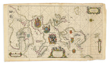
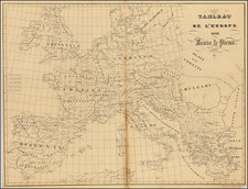
Rare English Sea Chart of Europe -- Second Printed English Sea Chart of Europe
Rare separately published Sea Chart of Europe, first published by Morden & Lea in about 1690, one of the earliest general sea charts of Europe published in England.
The map shows the sea coasts of Europe in Portloan style, with a large inset map of the easternmost part of the Mediterranean Sea. The map extends northwest to show a part of Iceland (spelled Iseland), northeast to Nova Zemla and south tot the coast of Africa.
The map is dedicated to Edward Orford, First Earl of Orford. Russell became First Lord of the Admiralty and Senior Naval Lord in the First Whig Junto in May 1694 and took a fleet out into the Mediterranean in June 1694, becoming the first English naval commander to spend the Winter at Cádiz (rather than sailing his squadron home in the autumn). He was elected Member of Parliament for Cambridgeshire in 1695 and was created Baron Shingay, Viscount Barfleur and Earl of Orford on 7 May 1697.
Lea's map is the second English language sea chart of the whole of Europe printed in England, preceded only by the very rare Ashley Chart.
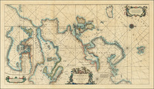
States of the Map
There are two states of the map:
- State 1: Imprint of Morden & Lea. Edward Russell is not yet called Earl of Orford.
- State 2: Morden's imprint has been erased, and Edward Russell's title is now Earl of Orford, a title granted in April 1697 (Post Man, issue 311, 24th-27th April).
- State 3: Carington Bowles imprint, title and dedication re-engraved, new country names added to the continent.
Rarity
The map is exceedingly rare. We note a single copy of state 2 offered a Jonathan Potter catalog in 1985 and an example of state 2 offered for Sale by Sothebys at Auction in 1974.
OCLC locates 1 example of State 1 (University of Melbourne), 1 example of State 2 (British Library) and 1 example of state 3 (Spanish National Library).
Philip Lea (fl. 1683-1700) was a central figure in the London map community at the end of the eighteenth century. He apprenticed under Robert Morden, with whom he later collaborated. Lea was made free of the Weavers Company in 1689. He was a publisher and a globe and instrument seller with ties to members of government. For example, Samuel Pepys lists him as his map advisor and colorist. He was not known primarily for his own original works, but for his reworking and reissuing of the work of others, particularly the county maps and world map of Christopher Saxton. He also acquired plates from John Seller, John Ogilby, and William Morgan, among others. Later in his career, he collaborated frequently with Herman Moll. After his death in 1700, Philip’s wife, Anne, carried on the business for several decades.