|
||

|

|
|

|
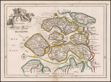
Interesting map of the Low Countries, notably includeing a large inset map of the ancient Arx Britannica, a fortress purportedly built by the Roman Emperor Caligula at the mouth of the Rhine River, which disappeared under the river's silt at the end of the 16th Century.
Moll's 1729 map of the United Provinces provides a snapshot of the region during the later stages of the Dutch Golden Age, which extended roughly from the late 16th century to the early 18th century. It encapsulates the Netherlands' geographic, political, and economic landscape during a period of unparalleled maritime power, global exploration, and cultural influence.
One of the most intriguing features of Moll's map is the large inset depiction of Arx Britannica, the Roman fortress said to have been constructed by Emperor Caligula at the Rhine River's mouth.This Roman fortress, once a potent symbol of Roman imperial power, had disappeared from sight by the end of the 16th century, engulfed by the accumulated silt of the Rhine River. The story of Arx Britannica's construction by the Romans, detailed on the map, strengthens the link between the present geography of the Netherlands and its past as a part of the Roman Empire. This layer of historical information accentuates the map's dual function as a geographical guide and a historical document.
The map's mention of Ortelius's reference to the fortress's foundation in 1552 adds yet another layer of intrigue. Abraham Ortelius was another important figure in the development of modern cartography. The brief reappearance of Arx Britannica above water in 1562, as mentioned in Moll's map, indicates a moment of renewed visibility for this ancient landmark before its final disappearance in 1588.
Herman Moll (c. 1654-1732) was one of the most important London mapmakers in the first half of the eighteenth century. Moll was probably born in Bremen, Germany, around 1654. He moved to London to escape the Scanian Wars. His earliest work was as an engraver for Moses Pitt on the production of the English Atlas, a failed work which landed Pitt in debtor's prison. Moll also engraved for Sir Jonas Moore, Grenville Collins, John Adair, and the Seller & Price firm. He published his first original maps in the early 1680s and had set up his own shop by the 1690s.
Moll's work quickly helped him become a member of a group which congregated at Jonathan's Coffee House at Number 20 Exchange Alley, Cornhill, where speculators met to trade stock. Moll's circle included the scientist Robert Hooke, the archaeologist William Stuckley, the authors Jonathan Swift and Daniel Defoe, and the intellectually-gifted pirates William Dampier, Woodes Rogers and William Hacke. From these contacts, Moll gained a great deal of privileged information that was included in his maps.
Over the course of his career, he published dozens of geographies, atlases, and histories, not to mention numerous sheet maps. His most famous works are Atlas Geographus, a monthly magazine that ran from 1708 to 1717, and The World Described (1715-54). He also frequently made maps for books, including those of Dampier’s publications and Swift’s Gulliver’s Travels. Moll died in 1732. It is likely that his plates passed to another contemporary, Thomas Bowles, after this death.
![Carte Nouvelle Des Pais Bas Catholiques Devises en Autrichiens, Franscois en hollandois…MDCCXCII [New Map of the Catholic Low Countries Divided into Austrians, French and Dutch... 1792.]](https://storage.googleapis.com/raremaps/img/small/92341.jpg)
![(France, Belgium, and Holland) Tabula Moderna Francie [Modern Map of France]](https://storage.googleapis.com/raremaps/img/small/101885.jpg)