|
||

|

|
|

|
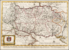
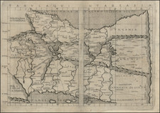
John Cary's map of Persia provides a comprehensive geographical portrayal of the region, combining high precision with remarkable clarity.
Cary's map depicted regions, including Irak Ajami (present-day western Iran), Corasaun (Khorasan), and the Kingdom of Caubul (Afghanistan) and Beloochistan (Balochistan), indicate the diverse political entities that existed within and around Persia. Each region is depicted with its distinct boundaries and significant cities, highlighting the geopolitical complexity of the area.
The map provides an excellent overview of the roads across the region, from Baghdad and Babylon in the west on through to Lahore and Karachi and Hyderabad in the east, illusrating the importance of the trading routes through the region.
Irak Ajami, located in the west of Persia, is marked by its significant cities, such as Tabriz and Isfahan, which were vital cultural and economic centers. Corasaun, an extensive region in northeastern Persia, is highlighted by the cities of Mashhad and Nishapur, among others. The Kingdom of Caubul and Beloochistan, east of Persia, showcase the then autonomous regions with their unique cultural and political identities.
Aderbijan (Azerbaijan), is also shown as a part of Persia. The major cities of Azerbaijan, such as Tabriz and Ardebil, are also clearly marked on Cary's map. During the period in focus, Tabriz served as a critical economic and cultural hub in the region. Its inclusion underscores its significance within the broader Persian socio-cultural and political landscape.
Azerbaijan, much like the aforementioned Corasaun, was also a region of strategic competition due to its location at the crossroads of major powers, including Russia and Persia, and its access to the Caspian Sea. This geopolitical competition would intensify in the latter half of the 19th century during the Great Game, a struggle for power and influence in Central Asia between the British Empire and the Russian Empire.
The adjacent Caspian Sea and Persian Gulf are also prominently displayed, attesting to their historical and strategic importance. The Caspian Sea, the world's largest enclosed inland body of water, and the Persian Gulf, a mediterranean sea in Western Asia, had considerable influence on Persia's trade, climate, and geopolitical relations. Their inclusion indicates their significance in defining Persia's geographic character and the region's interconnectedness with broader maritime networks.
The map also presents an accurate depiction of the major mountains, such as the Zagros and Elburz ranges, alongside significant roads and rivers, including the Karun and Zayandeh rivers. These geographical features shaped Persia's topography, climate, and communication networks, influencing the region's agricultural patterns, trade routes, and settlement distributions.
John Cary (1755-1835) was a British cartographer and publisher best known for his clean engraving and distinct style which influenced the entire map industry. Born in Wiltshire, John was apprenticed to an engraver in London. He started his own business by 1782 and moved to several premises before settling at 86 St James’s Street in 1820.
Cary had several significant collaborations during his career. John Wallis and Cary diversified Cary’s business to include broader publishing projects. Brother William and John made globes together, while brother Francis participated in the company’s engraving work. Finally, geologist William Smith and Cary developed and sold geological maps, some of the first of their kind. The pair also produced a notable series of county maps starting in 1819. Cary’s atlases, of English counties and the world, were the standard texts of the early nineteenth century. He was appointed surveyor of roads to the General Post Office in 1794, which led to the New Itinerary, first published in 1798.
John trained his son, George, in engraving and George and his other son, John Jr., took over the business in 1821. It was then known as G. and J. Cary and continued in trade until 1850. The firm’s materials were then acquired by George Frederick Cruchley and then Gall and Inglis. By the time John died in 1835, Cary was the authoritative name in private map publishing and his business was a leader in the field throughout the first half of the nineteenth century.