|
||

|

|
|

|
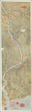
Anderson's Sectional Map of Western and Central Washington, U.S.A., compiled and published by The O.P. Anderson Map & Blue Print Co. Inc. in 1897, is a rare, separately issued map of Washington. Produced in Seattle, this detailed map covers the region extending from the Straits of Juan de Fuca to Willapa Harbor in the west and the Slate Creek Mining District in the northwest to the Yakima Indian Reservation in the southeast. It presents exceptional topographical details, particularly focusing on the mining regions in the eastern part of the map.
The map covers all or parts of Whatcom, Okanogan, San Juan, Skagit, Clallam, Island, Snohomish, Jefferson, Kitsap, King, Kittitas, Douglas, Chehalis, Mason, Thurston, Pierce, Pacific, Lewis, and Yakima counties. Various landmarks and points of interest are indicated, such as townships, sections, railroads, settlements, Indian reservations, drainage, mining districts, and glaciers.
Clear references are made to distinguish between state capitol, county seats, post offices, stations or landings (with no P.O.), railways, county boundaries, the international boundary, meandered rivers, rivers or creeks not meandered, and glaciers. This map provides a comprehensive and intricate perspective on the geography and infrastructure of Western and Central Washington at the end of the 19th century.
Rarity
The map is very rare, this being only the second example we have had.
![[Alaska to San Diego and San Qunitin, British Columbia] A Chart Shewing Part of the Coast of N.W. America, with the Tracks of His Majesty's Sloop Discovery and Armed Tender Chatham . . . (First Modern Map of the West Coast of North America)](https://storage.googleapis.com/raremaps/img/small/102067.jpg)
![[ California To Alaska -- Northwest Passage ] Quivirae Regnu cum alijs versus Borea](https://storage.googleapis.com/raremaps/img/small/60083.jpg)