


|
||

|

|
|

|
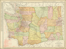
Detailed map of Washington, published in Chicago by Rand McNally.
Presenting an intriguing mix of cartographic precision and historical detailing, Rand McNally & Co.'s late 19th-century map of Washington offers a fine depiction of Washington's rapid growth following its 1889 statehood, including the establishment of new counties, the proliferation of railroad lines, and the vital mining and timber industries of the era.
A striking feature of the map is the intricate network of railroads crisscrossing the state, an indication of the transformative role rail transportation was playing in Washington's growth. The primary lines of the Northern Pacific Railway, the Great Northern Railway, and the Oregon Railroad and Navigation Company, among others, are clearly delineated. The map, thus, provides a comprehensive snapshot of the region's rail infrastructure, emphasizing its central role in connecting Washington's cities, supporting its industries, and facilitating its trade.
Washington's significant mining and timber industries are also well-represented on the map. Mining regions, especially those producing gold, silver, and coal, are accurately marked, revealing the areas of the state most economically active in this industry. The burgeoning timber industry, destined to become a mainstay of Washington's economy, is indicated by dense forests stretching across the western part of the state.
Rand McNally & Co. is a large American map and navigation company best known for its annual atlases. The company got its start in 1856, when William Rand opened a print shop in Chicago. He was joined in 1858 by a new employee, Andrew McNally. Together, the men established their namesake company in 1868. Originally, the company was intended to print the tickets and timetables for the trains running to and through Chicago; their first railway guide was published in 1869.
By 1870, they had shifted from just printing to publishing directories, travel guides, and newspapers. Their first map appeared in 1872 in a railway guide. The map was produced using a new wax engraving method, a cheaper process that gave the company an edge.
By 1880 Rand McNally had entered the education market with globes, wall maps, and geography texts for students. In 1923, Rand McNally published the first Goode’s World Atlas, named after its editor, Dr. J. Paul Goode. For generations afterward, this would be the standard classroom atlas.
In 1899, William Rand left the company, but McNally and his family remained, controlling the company for over a century. In 1904, they published their first road map intended for automobiles and by 1907 were publishing Photo-Auto Guides, which combined photography and mapping to help drivers. In 1924, they produced the Auto Chum, a precursor to their famous road atlases. Rand McNally would remain the leader in road maps and atlases throughout the twentieth century.
In 1937, Rand McNally opened its first store in New York City. Ever on the frontier of technology, Rand McNally pioneered the scribing process for printing tickets in 1958 and printed their first full-color road atlas in 1960. Arthur Robinson developed his now-famous projection of Rand McNally in 1969. By the 1980s, the company was exploring digital reproduction and digital databases of maps for truckers. In the 1990s, they lead the charge to develop trip-planning software and websites. Today, most of its products are available online or in a digital format, including maps for tablets and phones.

![[ Pacific Northwest - Northwest Passage ] Limes Occidentis Quivira et Anian. 1597](https://storage.googleapis.com/raremaps/img/small/71207.jpg)
![[ Used by '49ers To Travel To California ] Map of Oregon and Upper California from the surveys of John Charles Fremont and others authorities drawn by Charles Preuss 1848](https://storage.googleapis.com/raremaps/img/small/100557.jpg)