|
||

|

|
|

|
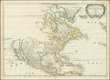
Herman Moll's influential 1720 map titled A New MAP of the North Parts of AMERICA claimed by FRANCE under y Names of LOUISIANA, MISSISSIPI, CANADA and NEW FRANCE with y Adjoyning Territories of ENGLAND and SPAIN provides a detailed perspective of North America during a time of territorial disputes and shifting power dynamics. It is an exceptional cartographic artifact that notably includes California as an island, a common misconception during the period.
The map is sourced from the original manuscripts of various geographers and explorers like Mr. Blackmore, M. Berisford, and Capt. Nairn. Moll also incorporates information from Guillaume Delisle's map published in Paris in 1718 to depict the southwest part of Louisiana. This map is significant as it demonstrates the French's territorial claims, which Moll invites English stakeholders to scrutinize for potential infringements on their own land holdings and alliances.
A unique feature of Moll's map is the clear delineation of the territories claimed by France, England, and Spain. The mapmaker uses different colors to represent each power's claimed territories. This color-coding of the geopolitical landscape was intended to provoke an examination of the French's incursions into lands that the English perceived as rightfully theirs.
In the top left corner, the map includes an engraved view of an Indian fort named Sasquesahanok. A detailed explanation of an expedition led by Captain T. Nairn is provided, showcasing the journey through Florida Neck with a party of thirty-three Famesee Indians. This expedition narrative includes geographical features, paths taken, locations where slaves were captured, and encounters with other Indian groups.
Moll's map is set in the Mercator projection, a common cartographic technique of the period. It is an attempt to provide the most accurate depiction of North America based on the latest observations and data. As such, it includes not only land territories but also maritime routes, such as the passage of the Spanish Flota from Vera Cruz to Havana, and then onwards to Spain.
The map also features two inset maps in the lower right corner, providing close-up views of the mouth of the Mississippi and Mobile Rivers, as well as the harbor of Annapolis Royal. These insets offer more detailed information about key geographical areas and add to the overall comprehensiveness of Moll's map.
In a broader context, Moll's map is an important cartographic document of the early 18th century. It reflects the territorial disputes and geopolitical tensions between the French, English, and Spanish in North America. It also offers detailed insight into the landscape, settlements, trading paths, and indigenous tribes of the region.
Finally, Moll's map is not just a geographical depiction but a political statement. Moll overtly critiques the French's territorial claims, and in doing so, defends the English's interests in North America. This map is a vivid testament to the intertwined nature of geography and politics in the colonial era.
State
Fifth of Six states, with the imprint amended to include Thomas (II) and John Bowles.
Herman Moll (c. 1654-1732) was one of the most important London mapmakers in the first half of the eighteenth century. Moll was probably born in Bremen, Germany, around 1654. He moved to London to escape the Scanian Wars. His earliest work was as an engraver for Moses Pitt on the production of the English Atlas, a failed work which landed Pitt in debtor's prison. Moll also engraved for Sir Jonas Moore, Grenville Collins, John Adair, and the Seller & Price firm. He published his first original maps in the early 1680s and had set up his own shop by the 1690s.
Moll's work quickly helped him become a member of a group which congregated at Jonathan's Coffee House at Number 20 Exchange Alley, Cornhill, where speculators met to trade stock. Moll's circle included the scientist Robert Hooke, the archaeologist William Stuckley, the authors Jonathan Swift and Daniel Defoe, and the intellectually-gifted pirates William Dampier, Woodes Rogers and William Hacke. From these contacts, Moll gained a great deal of privileged information that was included in his maps.
Over the course of his career, he published dozens of geographies, atlases, and histories, not to mention numerous sheet maps. His most famous works are Atlas Geographus, a monthly magazine that ran from 1708 to 1717, and The World Described (1715-54). He also frequently made maps for books, including those of Dampier’s publications and Swift’s Gulliver’s Travels. Moll died in 1732. It is likely that his plates passed to another contemporary, Thomas Bowles, after this death.
![United States of America [with] The Course of the River St. Laurence from Lake Ontarion to Manicouagan Point](https://storage.googleapis.com/raremaps/img/small/71643.jpg)
![[ English Plantations in North America ] A New Map of the most Considerable Plantations of the English In America Dedicated to His Highness William Duke of Glocester.](https://storage.googleapis.com/raremaps/img/small/98233.jpg)