


|
||

|

|
|

|
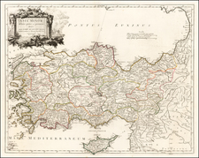
Philippe Buache's exquisite two-sheet antique map of Greece, published in Paris in 1745.
This grand map illustrates an extensive geographical canvas that includes Greece and extends to the western coastal regions of Asia Minor, reaching north to Illyris, Thracia, the western portion of the western side of the Black Sea.
One of the map's fascinating features is the depiction of the ancient road system, indicating the sophisticated infrastructure that underpinned the Greek and Roman civilizations. This network of roads, a lifeline connecting major cities and towns, highlights the strategic and cultural significance of these routes for trade, communication, and military expeditions.
This map offers a wealth of place names from Greek and Roman antiquity, symbolizing the extensive historical footprint of these formidable civilizations. It serves as a veritable who's who of ancient cities, prominently featuring landmarks like Sparta, Athenae (Athens), Rhodes, and Corinth.
Sparta, the city-state renowned for its military power and stoic philosophy, stands as a symbol of the disciplined and martial aspects of ancient Greek culture. Athenae (Athens), the birthplace of democracy and Western philosophy, showcases the intellectual and cultural prowess of the Greeks. The island-city of Rhodes, home to one of the seven wonders of the ancient world, highlights the magnificence and grandeur of Hellenistic culture. Corinth, one of the richest cities of antiquity, reflects the economic vitality of the Greek world.
In addition, the map extends into Asia Minor, which is present-day Turkey, revealing cities that were integral parts of the Greek and Roman worlds. This area, a melting pot of cultures and civilizations, contributed significantly to the wealth and diversity of ancient Mediterranean society.
Moving northwards, the map extends to the regions of Illyris, Thracia, and the western edges of the Pontus Euxinus and the Black Sea, the northernmost reaches of the Greek world. This area, which corresponds to modern-day northern Greece and the Balkans region, was home to several important cities, each with its unique blend of cultures, bridging the Greek, Roman, and indigenous Illyrian and Thracian civilizations.
Besides place names, the map vividly portrays the physical geography of the region. Numerous rivers, mountains, and cities are marked and named, painting a multifaceted picture of the landscapes that were the backdrop to some of history's most important events.
Philippe Buache (1700-1773) was one of the most famous French geographers of the eighteenth century. Buache was married to the daughter of the eminent Guillaume Delisle and worked with his father-in-law, carrying on the business after Guillaume died. Buache gained the title geographe du roi in 1729 and was elected to the Academie des Sciences in the same year. Buache was a pioneering theoretical geographer, especially as regards contour lines and watersheds. He is best known for his works such as Considérations géographiques et physiques sur les découvertes nouvelles dans la grande mer (Paris, 1754).
![[ Greece & Turkey ] Graecia Sophiani . . .](https://storage.googleapis.com/raremaps/img/small/76016.jpg)

![[Crete] El vero et nuovo disegno, di tutta la isola di Candia : ad cosmographiae studiosos N. St](https://storage.googleapis.com/raremaps/img/small/75163.jpg)