|
||

|

|
|

|
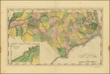
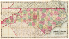
Striking map of the state of North Carolina from Anthony Finley's General Atlas.
Anthony Finley's 1823 map of North Carolina is a beautifully detailed representation of the state during a transformative period in its history. Hand-colored by counties, each district is colored to make them easily distinguishable from one another, creating a vibrant and engaging visual representation of the state's political divisions.
The map does not include the newly created Davidson County (1822).
The 1820s was a period of significant change and growth in North Carolina. The state's population was expanding westward, and new infrastructure, including roads and canals, was being developed to support this growth.
Finley's 1823 map of North Carolina, with its meticulous detailing and vibrant hand-coloring, offers more than just a geographical representation of the state. It serves as a historical artifact, capturing a moment of growth, change, and tension in North Carolina's history. The counties, both old and newly established, are testament to the shifting political and social landscape of the early 19th century.
Anthony Finley (1784-1836) was an American map publisher. Little is known about his life. He is presumed to have been born in Philadelphia, where he also died. A publisher, Finley was also involved in several Philadelphia civic and professional societies such as the Philadelphia Apprentices’ Library. He may have been in business as early as 1809 and his first publication dates from ca. 1811.
His first maps also date from this year, with two maps in Daniel Edward Clarke’s Travels in Various Countries of Europe, Asia, and Africa. The first atlas published by Finley appeared in 1818, the Atlas classica, or, Select maps of ancient geography, both sacred and profane, for the use of colleges and schools in the United States. He is best known for his A New General Atlas Comprising a Complete Set of Maps (1824), which was a bestseller. There were two editions in 1824, with annual editions until 1834.
Finley was part of the first generation of American publishers who produced high quality, precise maps on American soil. He was in competition with other Philadelphia publishers, for example Henry S. Tanner. Finley’s A New American Atlas Designed Principally to Illustrate the Geography of the United States of America (1826) closely mirrors Tanner’s A New American Atlas Containing Maps of the Several States of the North American Union, with similar groupings of maps; the main difference is the smaller scale of Finley’s maps. Finley printed two editions of this atlas.