|
||

|

|
|

|
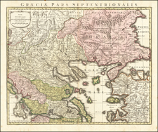
The Empire and Expedition of Alexander The Great
Nice example the "Map of Alexander the Great's Empire and Expedition," by the French cartographer Philippe Buache.
The map presents a detailed layout of the extensive empire of Alexander the Great, capturing its remarkable breadth from Greece in the west to the edges of India in the east. It meticulously details Alexander's extraordinary military expedition and the various regions he conquered during his short yet impactful reign from 336 to 323 BC.
Buache's map is based on historical texts, the most significant of which were the writings of Arrian, Diodorus Siculus, and other ancient historians who had painstakingly recorded the accounts of Alexander's expeditions. The map accurately mirrors the geographical knowledge of the time of Alexander, reflecting a world-view that was dramatically expanding due to the great Macedonian's campaigns. Notably, the map also includes the river systems, topographical features, and key cities of the empire, thus providing a comprehensive representation of the political and physical geography of Alexander's domain.
The map was constructed for scholars and educated classes studying the era of Alexander the Great. The map not only delineates the extent of his empire but also the routes he took during his notable expeditions. It provides a graphical narrative of his strategies and military successes, contributing to a deeper understanding of his impact on the history of Europe, Asia, and the Middle East. Furthermore, the map highlights the cross-cultural exchanges facilitated by Alexander's conquests, providing an overview of the beginnings of the Hellenistic era.
Philippe Buache. Buache was a celebrated cartographer in his time, serving as the official geographer to the king of France, and a pioneer in the introduction of a more analytical and scientific approach to cartography. His maps, often rich in geographical, geological, and historical details, marked a transitional period in the evolution of cartography, moving from decorative art towards a more practical, scientific discipline.
Philippe Buache (1700-1773) was one of the most famous French geographers of the eighteenth century. Buache was married to the daughter of the eminent Guillaume Delisle and worked with his father-in-law, carrying on the business after Guillaume died. Buache gained the title geographe du roi in 1729 and was elected to the Academie des Sciences in the same year. Buache was a pioneering theoretical geographer, especially as regards contour lines and watersheds. He is best known for his works such as Considérations géographiques et physiques sur les découvertes nouvelles dans la grande mer (Paris, 1754).
![A New Map of Turkey In Asia, Divided into its Provinces . . . 1801 [Cyprus]](https://storage.googleapis.com/raremaps/img/small/71232.jpg)