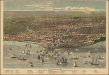


|
||

|

|
|

|
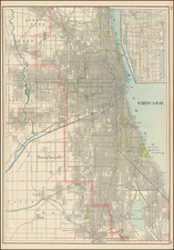
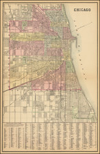
Samuel Augustus Mitchell Jr.'s plan of Chicago is an fine snapshot of the Windy City's rapid growth and urban development during the second half of the 19th century. Mitchell Jr., who took over the family cartographic business from his father, was renowned for his meticulously detailed and accurate maps, and this plan of Chicago is no exception.
The map is color-coded by wards, providing an immediate visual representation of the city's political divisions. Not just a political map, it also illustrates the city's burgeoning transit system, complete with railway lines, stations, and horse-drawn streetcar routes. The level of detail is impressive, with the names of streets, public squares, parks, and important buildings all carefully annotated. The map includes practical street guide at the bottom.
The map also serves as a testament to the history of Chicago's local metropolitan transit system in the 19th century. Chicago was one of the first cities in the United States to adopt a comprehensive public transit system, beginning with horse-drawn streetcars in the 1850s, followed by cable cars in the 1880s, and finally the introduction of electric streetcars by the end of the century. The routes of these transit systems, clearly depicted on Mitchell Jr.'s map, played a significant role in shaping the city's growth and development.
The growth of Chicago between 1850 and 1900 was nothing short of extraordinary. In 1850, the city had a population of just over 30,000 people. By 1900, that number had skyrocketed to nearly 1.7 million, making Chicago the second-largest city in the United States. This rapid expansion, driven by industrialization and immigration, is evidenced in Mitchell Jr.'s map, which shows a densely built-up city center and ever-expanding suburbs.
Samuel Augustus Mitchell Jr. inherited the Mitchell Company from his father in 1860. For over thirty years, the company had specialized in the production of school atlases and wall maps of America. They were one of the pioneers on engraving on steel plates. In 1860, Samuel Jr. released the New General Atlas, which had been compiled in house and replaced a previous atlas by Tanner. The elder Mitchell died in 1868 and Samuel Jr. continued the business until the 1890s. At its height, the Mitchell Company employed 250 people and sold 400,000 publications annually.