|
||

|

|
|

|
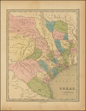
The Republic of Texas in 1838
Nice example of this early edition of Bradford's large map of the Republic of Texas, first published in 1838.
Bradford's 1838 map of the Republic of Texas is a remarkable and detailed cartographic representation of a crucial period in Texas history. It provides an engaging snapshot of the region during the earliest years of the Republic, a tumultuous era marked by the Texan's struggle for independence, early nationhood, and the beginning stages of its eventual annexation to the United States.
The map is an impressive visual display, meticulously charting various territories, settlements, and land features throughout the Republic. The map shows distinct territories dedicated to land grants, indicating the distribution of land to settlers by the Republic of Texas and Mexico prior to the Texas Revolution. It suggests the political mechanisms of colonization and migration during this period, with land grants acting as a significant incentive for settlers moving west.
Further, Bradford's map includes areas marked as "Comanche Indians" land, highlighting the significant presence of the Comanche Nation in Texas during this era. It not only acknowledges the presence of Native American groups but also emphasizes their significant influence and dominion over large parts of the region.
Major rivers like the Rio Grande, Brazos, and the Colorado are clearly distinguished, marking out the lifelines of the early Texas landscape. Towns and settlements are pinpointed across the territory. Also shown are several Native American villages.
The map thus stands as an invaluable resource for understanding the Republic of Texas (1836-1845). From the Texas Revolution in 1835-1836, through the drafting of the Republic's constitution, to the early negotiations of annexation with the United States starting around 1837, this period was one of profound change and development. Bradford's 1838 map captures a snapshot of this era, immortalizing a moment in time when Texas was carving its own path as a nation.
Thomas Gamaliel Bradford (1802-1887) was an American geographic publisher. He hailed from Bradford, Massachusetts and began his publishing career by working for the America Encyclopedia. Then, he edited and republished the Atlas Designed to Illustrate the Abridgement of Universal Geography, Modern & Ancient, which had originally been offered in French by Adrian Balbi. In 1835, he published another atlas, A Comprehensive Atlas: Geographical, Historical & Commercial, and, in 1838, An Illustrated Atlas Geographical, Statistical and Historical of the United States and Adjacent Countries. His interests were primarily in educational publishing and he was one of the first mapmakers to show Texas as an independent country.
![[Matagorda Bay] Bahia De S. Bernardo](https://storage.googleapis.com/raremaps/img/small/54374.jpg)
![(Lasalle's Final Expedition) Dernieres Decouvertes dans L'Amerique Septentrionale de M. De La Sale [i.e., La Salle], Mises au jour par M. le Chevalier Tonti, Gouverneur du Fort Saint Louis, aux Islinois.](https://storage.googleapis.com/raremaps/img/small/69476.jpg)