


|
||

|

|
|

|
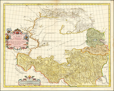
The 1745 edition of "Carte de Perse," engraved by P. Starck-man and edited by Philippe Buache, is an instructive artifact of the geographical understanding of Persia and the Caspian Sea during the 18th century, initially drafted for the use of the French king by Guillaume De L'Isle, the Royal Geographer.
This edition of "Carte de Perse," first created by Guillaume De L'Isle in December 1724, and later revised by his son-in-law and successor, Philippe Buache, in April 1745, presents a detailed cartographic representation of Persia (modern-day Iran). The map provides a comprehensive view of the region, demonstrating the scope and precision of European geographical knowledge during the Enlightenment.
The map is particularly distinguished by its detailed depiction of towns, trade routes, islands, and deserts. The major trade routes, crucial to the economy and cultural exchange of the period, are meticulously marked, reflecting the importance of Persia as a hub in the global trade network of the 18th century. The delineation of deserts and islands further illuminates the intricate physical geography of the region, providing a richly textured understanding of the environmental challenges and opportunities faced by its inhabitants.
The "Carte de Perse" stands as a testament to the cartographic expertise of De L'Isle and Buache, who were renowned for their scientific approach to map-making. Published in Paris, the map represents an advanced understanding of the region, as well as a significant contribution to the broader European project of charting and understanding the wider world. As such, it encapsulates an intriguing intersection of geography, politics, and cultural perception in 18th-century Europe.
Guillaume De L'Isle (1675-1726) is probably the greatest figure in French cartography. Having learned geography from his father Claude, by the age of eight or nine he could draw maps to demonstrate ancient history. He studied mathematics and astronomy under Cassini, from whom he received a superb grounding in scientific cartography—the hallmark of his work. His first atlas was published in ca. 1700. In 1702 he was elected a member of the Academie Royale des Sciences and in 1718 he became Premier Geographe du Roi.
De L'Isle's work was important as marking a transition from the maps of the Dutch school, which were highly decorative and artistically-orientated, to a more scientific approach. He reduced the importance given to the decorative elements in maps, and emphasized the scientific base on which they were constructed. His maps of the newly explored parts of the world reflect the most up-to-date information available and did not contain fanciful detail in the absence of solid information. It can be fairly said that he was truly the father of the modern school of cartography at the commercial level.
De L’Isle also played a prominent part in the recalculation of latitude and longitude, based on the most recent celestial observations. His major contribution was in collating and incorporating this latitudinal and longitudinal information in his maps, setting a new standard of accuracy, quickly followed by many of his contemporaries. Guillaume De L’Isle’s work was widely copied by other mapmakers of the period, including Chatelain, Covens & Mortier, and Albrizzi.
Philippe Buache (1700-1773) was one of the most famous French geographers of the eighteenth century. Buache was married to the daughter of the eminent Guillaume Delisle and worked with his father-in-law, carrying on the business after Guillaume died. Buache gained the title geographe du roi in 1729 and was elected to the Academie des Sciences in the same year. Buache was a pioneering theoretical geographer, especially as regards contour lines and watersheds. He is best known for his works such as Considérations géographiques et physiques sur les découvertes nouvelles dans la grande mer (Paris, 1754).

![[ Tibet / Nepal / Himalyas ] Carte von Tibet nach den neuesten Nachrichten entworfen 1790](https://storage.googleapis.com/raremaps/img/small/86165.jpg)
![[Iran & Iraq] Quinta Asie Tabula](https://storage.googleapis.com/raremaps/img/small/75299.jpg)