|
||

|

|
|

|
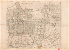
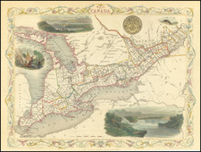
Detailed map of Ontario with Parts of New-York, Pennsylvania and Michigan, published in London By Letts.
This was the era of Canadian Confederation, with the Dominion of Canada established just a few years prior in 1867. The map illustrates this newfound federal entity, with its territorial divisions clearly demarcated. Its focus on Ontario, the most populous Canadian province, alongside parts of New-York, Pennsylvania, and Michigan, underscores the close ties and intricate interactions across the Canada-US border.
The map's detailed depiction of these regions, including their key cities, transportation networks, and natural features, reflects the increasing importance of infrastructure and urban centers during this period. The growth of the railway system, in particular, had profound implications for the development and expansion of settlements and trade, tying together distant parts of the continent and fuelling economic prosperity.