|
||

|

|
|

|
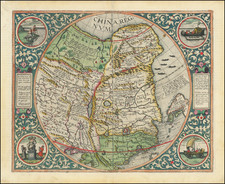
The First Printed Folio Map of Japan to show the Maarten De Vries' discoveries in Hokkaido and the Kurile Islands.
This important map of Japan shows the three southern main islands, Honshu, Kyushu and Shikoku in a relatively advanced form, broadly familiar to the modern eye. Many cities and towns are labelled, including the capital city of Meako (Kyoto) and Iedo (Tokyo).
The revolutionary features of the map are the 'Landt van Eso' (the northern part of Hokkaido), which was then outside of the Japanese state and further north, 'Compagnies Land' named after the Dutch East India Company, is a somewhat fanciful rendering of the island of Iturup in the Kurile Islands. These areas would not be accurately charted until the 1787 visit of the French explorer Comte de La Perouse.
Korea, which was made 'off-limits' to foreigners by the ruling Joseon Dynasty, is little understood and is shown to be an island. The sole place name in Korea is 'Tauxem', located approximately at the modern-day site of Pyongyang.
The cartouche depicts five robed men, holding bows, flowers, and swords, in a tableau likely representing Jesuit missionaries. The Jesuits played a critical role in bridging European and East Asian cultures during this period, and their inclusion in the map foregrounds the entwined histories of exploration, mission work, and cartography.
The genealogy of the map is very interesting. The basic template for the southern main islands was Abraham Ortelius' Iaponiae Insulae Descriptio, which was first printed in the 1595 edition of his Theatrum Orbis Terrarum. Ortleius, in turn, based the map on a manuscript sent to him in 1592 by Luís Teixeira, a Portuguese Jesuit who served as the official geographer to Spain's King Philip II.
In 1643, the Dutch adventurer Maarten Gerritsz de Vries (1589-1647), aboard his ship the Castricum, sailed around the waters of Honshu and Kyushu. However, by accident (driven by a storm), De Vries became the first European to visit Hokkaido, the Kurile Islands and Sakhalin.
Jansson acquired manuscript versions of De Vries's charts via his contacts with the Dutch East India Company (the VOC), and first published a small-sized version of the map as part of his Atlas Minor (1651). Jansson issued the first edition of the fine present folio-sized version of the map in 1658.
Jan Jansson (1588-1664) was a towering figure of the Golden Age of Dutch Cartography. He married the daughter of the tenement Amsterdam cartographer Jodocus Hondius and transformed the Hondius firm into a powerhouse of geographical publications. Jansson most notably published the Atlas Novus (1638) and the Atlas Major (1660), the 11 volumes of which included a town atlas, a hydrographic atlas, an atlas of the ancient world, and Andreas Cellarius's incomparable celestial atlas. Jansson's works were rivaled only by those of his arch-nemesis Joan Blaeu.
Jannson's map is one of the most important 17th Century maps of Japan, and an essential element of any collection.
North Pacific chimeras: Yesso, De Gama, and Compagnie Land
The etymology of the idiom Yesso (Eso, Yeco, Jesso, Yedso) is most likely the Japanese Ezo-chi; a term used for the lands north of the island of Honshu. During the Edō period (1600-1886), it came to represent the ‘foreigners’ on the Kuril and Sakhalin islands. As European traders came into contact with the Japanese in the seventeenth century, the term was transferred onto European maps, where it was often associated with the island of Hokkaido. It varies on maps from a small island to a near-continent sized mass that stretches from Asia to Alaska.
The toponym held interest for Europeans because the island was supposedly tied to mythic riches. Father Francis Xavier (1506-1552), an early Jesuit missionary to Japan and China, related stories that immense silver mines were to be found on a secluded Japanese island; these stories were echoed in Spanish reports. The rumors became so tenacious and tantalizing that Abraham Ortelius included an island of silver north of Japan on his 1589 map of the Pacific.
Yesso is often tied to two other mythical North Pacific lands, Gamaland and Compagnies Land. Juan de Gama, the grandson of Vasco de Gama, was a Portuguese navigator who was accused of illegal trading with the Spanish in the East Indies. Gama fled and sailed from Macau to Japan in the later sixteenth century. He then struck out east, across the Pacific, and supposedly saw lands in the North Pacific. These lands were initially shown as small islands on Portuguese charts, but ballooned into a continent-sized landmass in later representations.
Several voyagers sought out these chimerical islands, including the Dutchmen Matthijs Hendrickszoon Quast in 1639 and Maarten Gerritszoon Vries in 1643. Compagnies Land, often shown along with Staten Land, were islands sighted by Vries on his 1643 voyage. He named the islands for the Dutch States General (Staten Land) and for the Dutch East India Company (VOC) (Compagnies, or Company’s Land). In reality, he had re-discovered two of the Kuril Islands. However, other mapmakers latched onto Compagnies Land in particular, enlarging and merging it with Yesso and/or Gamaland.
In the mid-eighteenth century, Vitus Bering, a Danish explorer in Russian employ, and later James Cook would both check the area and find nothing. La Perouse also sought the huge islands, but found only the Kurils, putting to rest the myth of the continent-sized dream lands.
The sequence of events and maps that led California to be portrayed as an island are much clearer than another famous peninsula-turned-island, Korea. Korea is briefly mentioned in the thirteenth century by Marco Polo as Cauli (Kauli), but otherwise Korea was not described again for European audiences until the late-sixteenth century.
As with Japan and China, most of the earliest bits of information about Korea came from the Jesuits sending letters sent back from East Asia. However, the Jesuits were not actually stationed in Korea; they could only glean impressions from Chinese and Japanese sources. For example, Father Luis Frois wrote of Korea in the context of a war with Japan in 1578. Frois explained that Korea was separated from Japan by a sliver of sea. It had previously been understood to be an island, he explained, but was now known to be a peninsula. However, why Korea was thought to be an island, by who, and how it was found to be a peninsula was not shared with Frois’ curious readers back in Europe.
The first known European to visit Korea was also a Jesuit, Father Gregorio des Cespedes. He accompanied Japanese troops during another war with Korea in 1592. The territory did not agree with Cespedes, who found it bitingly cold. He did not mention anything about the Korean peoples or their geography.
Travel writers, those who actually traveled and those who were more drawn to the armchair voyage, also wrote about Korea. Jan Huygen van Linschoten spent several years in Goa, India, where he had access to Spanish and Portuguese sources. In his Itinerario, first published in German and English in 1598, he suggests Korea is a large island called Core. Richard Hakluyt read the Jesuit letters, which were republished in sets of annual letters. In the second edition of his Principal Navigations (1599), Hakluyt included the information from Frois and Cespedes, scant as it was.
Given the relative dearth of source material, it is not surprising that early maps by Münster, Mercator and Ortelius omitted Korea entirely. The first map to show Korea was Orbis Terrarum Typus de Integro Multis in Locis Emendatus by Petrus Plancius (1594). It included “Corea” as a long, skinny peninsula barely attached to the northeast corner of China. Edward Wright, in the map accompanying Hakluyt’s Principal Navigations, adopted a similar depiction of Korea, as did other mapmakers from the 1590s onward.
Interestingly, the map that accompanied Linschoten’s Itinerario, by Arnold Floris van Langren, shows Korea as a large, round island. However, no other mapmaker is known to have followed this example. Another early island depiction that was widely adopted was that of Luis Teixeira in the 1595 edition of Ortelius’ Theatrum Orbis Terrarum. The long, thin island was used by several cartographers, including Jodocus Hondius, in the seventeenth century. Blaeu also used the Teixeira model before creating a new Korea in later maps that looked like a bat hanging from China, separated from the mainland by the thinnest of waterways.
Confusion over island vs. peninsula continued across seventeenth-century maps. For example, John Speed includes three separate versions of Korea across four maps in his A Prospect of the Most Famous Parts of the World (1626). It is shown on the Teixeira island model, as a thin peninsula, and as a blunt island. These various hypotheses as to the shape of Korea continued to coexist for decades.
Finally, in the 1650s, Father Martino Martini gathered more information and created a new map of Korea. In China from 1642 to 1651, Martini spent a good deal of time with Chinese maps and their makers. Thus, he created new maps showing Korea as a thicker, nearly rectangular peninsula in Bellum Tartaricum (1654) and the Atlas Sinensis (1655).
Also in the 1650s, a Dutch sailor named Hendrick Hamel was shipwrecked on Jeju, an island near southern Korea. Hamel and his fellow survivors would spend thirteen years in Korea, escaping to Nagasaki in 1666. He wrote about the ordeal in a journal that was published in 1668. Although it lacked maps, the ample descriptions confirmed that Korea gave a detailed, first-hand view of Korean geography and culture.
Nevertheless, several maps were published in the early eighteenth-century showing Korea as an island. The island myth, which most likely stemmed from a misreading of Japanese and Chinese maps by early Jesuits, proved to be quite entrenched. Only in 1735 did Jean Baptiste Bourguignon d’Anville produce a map with a roughly accurate outline of the peninsula and a relatively detailed interior.
Jan Janssonius (also known as Johann or Jan Jansson or Janszoon) (1588-1664) was a renowned geographer and publisher of the seventeenth century, when the Dutch dominated map publishing in Europe. Born in Arnhem, Jan was first exposed to the trade via his father, who was also a bookseller and publisher. In 1612, Jan married the daughter of Jodocus Hondius, who was also a prominent mapmaker and seller. Jonssonius’ first maps date from 1616.
In the 1630s, Janssonius worked with his brother-in-law, Henricus Hondius. Their most successful venture was to reissue the Mercator-Hondius atlas. Jodocus Hondius had acquired the plates to the Mercator atlas, first published in 1595, and added 36 additional maps. After Hondius died in 1612, Henricus took over publication; Janssonius joined the venture in 1633. Eventually, the atlas was renamed the Atlas Novus and then the Atlas Major, by which time it had expanded to eleven volumes. Janssonius is also well known for his volume of English county maps, published in 1646.
Janssonius died in Amsterdam in 1664. His son-in-law, Johannes van Waesbergen, took over his business. Eventually, many of Janssonius’ plates were sold to Gerard Valck and Pieter Schenk, who added their names and continued to reissue the maps.
![[Clans Assigned to Defence Duty on Land and Sea in lzu, Sagami, Musashi, Kazusa, Shimofusa, and Awa Provinces] [lzu, Sagami, Musashi, Kazusa, Shimofusa, Awa kairiku okatame]](https://storage.googleapis.com/raremaps/img/small/55562.jpg)