|
||

|

|
|

|
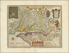
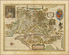
Virginiae Partis australis, et Floridae partis orientalis, interjacentiumqus regionum Nova Descriptio is a striking exemplar of Jan Jansson's cartographic work, portraying the Southeastern United States with a keen focus on the Carolinas. Dating to the early 17th century, this map mirrors the contemporary Dutch understanding of the region and the geopolitical tension between the French and English colonial powers. Regional control is subtly indicated through the coat of arms of both countries, creating a fascinating blend of geography and history.
The map offers a broad coverage from the mouth of the Chesapeake Bay to Georgia, capturing the diverse terrain and settlements of the time. It builds upon and refines the 1606 Mercator-Hondius map of the Carolinas, illustrating the advancements in cartographic knowledge and techniques. The improvements are particularly apparent in the northern part of the map, from Porto Royal to Cape Fear, which is more accurately represented in terms of direction and positioning. A key highlight of the map is its rendition of the Outer Banks region, borrowing placenames from both Hondius and Gerritsz. Although the Chesapeake Bay appears as a modest bay, following the unexplored portrayal on Hondius' 1606 map, it adds more placenames drawn from Smith's map and an unknown English source.
The historical context of the map is captivating, marking the period of growing French and English colonization efforts in the 1560s. It reflects the interplay of European power dynamics and their impacts on the newly discovered regions. The map also sheds light on the gradual refinement of geographical knowledge and the influence of early cartographers like Hessel Gerritsz and John Smith on Jansson's work. The mention of Newport News, founded in 1621, signifies the emerging English settlements and their imprints on the landscape.
In terms of aesthetic features, the map includes several conjectural lakes in the interior, conforming to the cartographic norms of the time. It is adorned with a large cartouche, two coats of arms, a pair of compass roses, and several sailing ships. The map bears a striking resemblance to Blaeu's map of the region, the only distinguishable difference being the erroneous longitudinal number 200 in the lower right corner on Blaeu's map, while Jansson's map correctly presents 300. Overall, Virginiae Partis australis, et Floridae partis orientalis, interjacentiumqus regionum Nova Descriptio stands as a compelling testimony to Jansson's precision, keen observational ability, and artistry.
Jan Janssonius (also known as Johann or Jan Jansson or Janszoon) (1588-1664) was a renowned geographer and publisher of the seventeenth century, when the Dutch dominated map publishing in Europe. Born in Arnhem, Jan was first exposed to the trade via his father, who was also a bookseller and publisher. In 1612, Jan married the daughter of Jodocus Hondius, who was also a prominent mapmaker and seller. Jonssonius’ first maps date from 1616.
In the 1630s, Janssonius worked with his brother-in-law, Henricus Hondius. Their most successful venture was to reissue the Mercator-Hondius atlas. Jodocus Hondius had acquired the plates to the Mercator atlas, first published in 1595, and added 36 additional maps. After Hondius died in 1612, Henricus took over publication; Janssonius joined the venture in 1633. Eventually, the atlas was renamed the Atlas Novus and then the Atlas Major, by which time it had expanded to eleven volumes. Janssonius is also well known for his volume of English county maps, published in 1646.
Janssonius died in Amsterdam in 1664. His son-in-law, Johannes van Waesbergen, took over his business. Eventually, many of Janssonius’ plates were sold to Gerard Valck and Pieter Schenk, who added their names and continued to reissue the maps.
![[Rare First State] Novissima Tabula Regionis Ludovicianae Gallice dictae la Louisiane . . .](https://storage.googleapis.com/raremaps/img/small/72622.jpg)

![[ Fredericksburg, Virginia ] Le Port de Fredericsbourg dans l'Amerique](https://storage.googleapis.com/raremaps/img/small/86570.jpg)