|
||

|

|
|

|
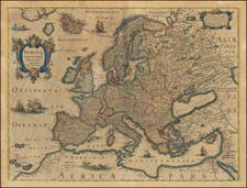
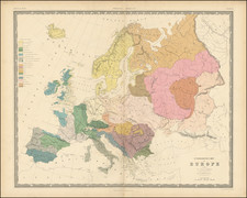
Striking example of the Mercator-Hondius map of Celtic Europe, based upon Abraham Ortelius' map, which appeared in his Parergon.
The map is perhaps most noteworthy for its many references to places named in classical times, including the following:
Arctoa Regio sub Hyperborei et Pterophori (Arctic Regions): This Latin phrase can be roughly translated as "The Arctic Region under the Hyperboreans and the Wing-Bearers." The Hyperboreans were a mythical people described by the ancient Greeks who lived far to the North, beyond the North Wind (Boreas). The identity of the Pterophori, or "Wing-Bearers," is less clear, but they could represent another mythical tribe or possibly a reference to a specific animal or symbol associated with the region.
Amalchium Mare Hecataeo: This refers to a sea named by Hecataeus (Amalchium Mare), who was an early Greek geographer. "Morimarusa a Cimbris vocatur" appears to suggest that this sea was also called "Morimarusa" by the Cimbri. The Cimbri were an ancient tribe who lived in the Jutland Peninsula in what is now Denmark. Morimarusa and may derive from the language of the Cimbri.
Fortunatae Insulae, sive Beatorum quae et Glessariae item Electrides (from Pliny): The Fortunate Islands, also known as the Isles of the Blessed, were a part of ancient Greek and Roman mythology, believed to be paradisiacal islands where the heroes of myth were sent to live out their immortality. This phrase suggests a connection with the Glessariae and Electrides islands, whose precise identity and location have been lost to history.
Insulae . . . Thule credita: Thule was the name given by ancient Greek and Roman geographers to the most northerly region then known. Its exact location is still a matter of debate among historians, with proposed locations including Iceland, Norway, and the Shetland Islands.
Caledonius oceanus: The term "Caledonius Oceanus" refers to the ancient Roman name for what is now known as the North Sea and the waters surrounding Scotland. The Romans named this body of water after the Caledonii tribe, who were one of the tribal confederations of indigenous inhabitants of what is now Scotland.
Jan Janssonius (also known as Johann or Jan Jansson or Janszoon) (1588-1664) was a renowned geographer and publisher of the seventeenth century, when the Dutch dominated map publishing in Europe. Born in Arnhem, Jan was first exposed to the trade via his father, who was also a bookseller and publisher. In 1612, Jan married the daughter of Jodocus Hondius, who was also a prominent mapmaker and seller. Jonssonius’ first maps date from 1616.
In the 1630s, Janssonius worked with his brother-in-law, Henricus Hondius. Their most successful venture was to reissue the Mercator-Hondius atlas. Jodocus Hondius had acquired the plates to the Mercator atlas, first published in 1595, and added 36 additional maps. After Hondius died in 1612, Henricus took over publication; Janssonius joined the venture in 1633. Eventually, the atlas was renamed the Atlas Novus and then the Atlas Major, by which time it had expanded to eleven volumes. Janssonius is also well known for his volume of English county maps, published in 1646.
Janssonius died in Amsterdam in 1664. His son-in-law, Johannes van Waesbergen, took over his business. Eventually, many of Janssonius’ plates were sold to Gerard Valck and Pieter Schenk, who added their names and continued to reissue the maps.
![[ Holy Roman Empire ] Germania, Non ea tantum quae Rheno, Vistula, Danubio, mariqz Germanico Veteribus claudebatur; Sed tota illa continens quae hodie communiter Germanica lingua utitur . . .](https://storage.googleapis.com/raremaps/img/small/99236.jpg)