|
||

|

|
|

|
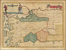
A fine example of the 1745 edition of De L'Isle's influential map, engraved by H. van Loon, of the Turkish Empire and Arabian Peninsula.
This map, created by renowned French cartographer Guillaume de L'Isle and later updated by Phillipe Buache in 1745, provides valuable insight into the evolving understanding of the geography of the Turkish Empire, Arabian Peninsula, Mediterranean, Central Asia, and parts of Ukraine and Egypt. De L'Isle, a member of the French Academy of Sciences, based his work on the most recent memoirs and observations available to him, ensuring the map's accuracy for its time.
In the lower right-hand corner, the 1745 edition names Buache, De L'Isle's son-in-law and fellow geographer. It is worth noting that the title of the map still carries the date 1701, despite the updated imprint that clearly indicates its 1745 edition.
Guillaume De L'Isle (1675-1726) is probably the greatest figure in French cartography. Having learned geography from his father Claude, by the age of eight or nine he could draw maps to demonstrate ancient history. He studied mathematics and astronomy under Cassini, from whom he received a superb grounding in scientific cartography—the hallmark of his work. His first atlas was published in ca. 1700. In 1702 he was elected a member of the Academie Royale des Sciences and in 1718 he became Premier Geographe du Roi.
De L'Isle's work was important as marking a transition from the maps of the Dutch school, which were highly decorative and artistically-orientated, to a more scientific approach. He reduced the importance given to the decorative elements in maps, and emphasized the scientific base on which they were constructed. His maps of the newly explored parts of the world reflect the most up-to-date information available and did not contain fanciful detail in the absence of solid information. It can be fairly said that he was truly the father of the modern school of cartography at the commercial level.
De L’Isle also played a prominent part in the recalculation of latitude and longitude, based on the most recent celestial observations. His major contribution was in collating and incorporating this latitudinal and longitudinal information in his maps, setting a new standard of accuracy, quickly followed by many of his contemporaries. Guillaume De L’Isle’s work was widely copied by other mapmakers of the period, including Chatelain, Covens & Mortier, and Albrizzi.
Philippe Buache (1700-1773) was one of the most famous French geographers of the eighteenth century. Buache was married to the daughter of the eminent Guillaume Delisle and worked with his father-in-law, carrying on the business after Guillaume died. Buache gained the title geographe du roi in 1729 and was elected to the Academie des Sciences in the same year. Buache was a pioneering theoretical geographer, especially as regards contour lines and watersheds. He is best known for his works such as Considérations géographiques et physiques sur les découvertes nouvelles dans la grande mer (Paris, 1754).
![[Pictorial Map of the United Arab Republic] Kharitat Musawwarat al-Jumhuriya al-'Arabiya al-Muttahida / خريطة مصورة الجمهورية العربية المتحدة](https://storage.googleapis.com/raremaps/img/small/55146.jpg)
![[Early Trekking Map] Latest Map of Kathmandu to Tibet](https://storage.googleapis.com/raremaps/img/small/51007.jpg)