|
||

|

|
|

|
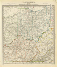
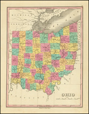
The 1898 rendition of Rand, McNally & Co's New Business Atlas Map of Ohio offers an intricate portrayal of the state's geographical landscape, depicting cities, counties, railroads, and rivers. One striking feature is the detailed inset map of Hamilton County, home to Cincinnati, which, according to the 1890 census, was the state's most populous city.
During this period, Ohio was experiencing a significant economic boom, spurred by an expansion in industrial activities and the proliferation of railroads. Ohio's strategic location, robust manufacturing sector, and rich agricultural output positioned it as a linchpin in America's late 19th-century economic growth. This period witnessed burgeoning urban centers such as Cincinnati, which is highlighted prominently in this map's inset.
The map displays the physical and political divisions of the state with distinct color codifications for each county. This feature not only enhances readability but also emphasizes the geopolitical landscape of Ohio as it existed in 1898. The intricacies of the railroad lines underscore the transportation networks vital to the movement of goods and people during this industrious period.
Rand, McNally & Co., renowned for their precise cartographic works, demonstrates their commitment to detail and accuracy with this map. The company's business atlases were highly regarded for their use of innovative color-printing technology and were commonly used as authoritative references in commercial and educational contexts.
Rand McNally & Co. is a large American map and navigation company best known for its annual atlases. The company got its start in 1856, when William Rand opened a print shop in Chicago. He was joined in 1858 by a new employee, Andrew McNally. Together, the men established their namesake company in 1868. Originally, the company was intended to print the tickets and timetables for the trains running to and through Chicago; their first railway guide was published in 1869.
By 1870, they had shifted from just printing to publishing directories, travel guides, and newspapers. Their first map appeared in 1872 in a railway guide. The map was produced using a new wax engraving method, a cheaper process that gave the company an edge.
By 1880 Rand McNally had entered the education market with globes, wall maps, and geography texts for students. In 1923, Rand McNally published the first Goode’s World Atlas, named after its editor, Dr. J. Paul Goode. For generations afterward, this would be the standard classroom atlas.
In 1899, William Rand left the company, but McNally and his family remained, controlling the company for over a century. In 1904, they published their first road map intended for automobiles and by 1907 were publishing Photo-Auto Guides, which combined photography and mapping to help drivers. In 1924, they produced the Auto Chum, a precursor to their famous road atlases. Rand McNally would remain the leader in road maps and atlases throughout the twentieth century.
In 1937, Rand McNally opened its first store in New York City. Ever on the frontier of technology, Rand McNally pioneered the scribing process for printing tickets in 1958 and printed their first full-color road atlas in 1960. Arthur Robinson developed his now-famous projection of Rand McNally in 1969. By the 1980s, the company was exploring digital reproduction and digital databases of maps for truckers. In the 1990s, they lead the charge to develop trip-planning software and websites. Today, most of its products are available online or in a digital format, including maps for tablets and phones.
![[ Toledo, Ohio ] Toledo and Lake Erie Park and Casino](https://storage.googleapis.com/raremaps/img/small/76621.jpg)