


|
||

|

|
|

|
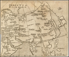
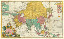
This captivating map of Asia by Herman Moll is a fine example of early 18th-century cartography, dedicated to William Lord Cowper, the Lord High Chancellor of Great Britain at the time. The map offers a wealth of detail, showcasing the most accurate observations available during that period. It features insets of various regions such as the Hellespont or the Straits of Constantinople by Capt. Bamburg, the Gulf of Smirna, Bombay and Sallset Island, and the Hugly River from Buffalow Point to Hugly Towne.
In the upper right corner, an inset plan explains that the supposed North Coast of Asia is continued there, to avoid excessive contraction of the scale. Below this plan, two more insets can be found, depicting a part of Chusan Island in China (which shows a British Factory), and Amoy Island. The map also notes the "Sea of Corea."
This map is an excellent representation of the decorative and detailed cartography that characterized Herman Moll's work. It is an Overton edition, bearing the names of Thomas Bowles, John Bowles, and Phillip Overton. The map provides a comprehensive view of Asia, with English nomenclature and notes on Jesuit explorations in the Philippines. It even acknowledges the uncertainty surrounding the northern parts of Japan, whether they are attached to the mainland or form an island. The map's coastal regions illustrate various ocean currents on a monthly basis.
This map is the third of five states and can be dated to around 1726.
As one of the most decorative large-format maps of Asia ever published, it stands as a testament to the skill and craftsmanship of the cartographers of that time.
Herman Moll (c. 1654-1732) was one of the most important London mapmakers in the first half of the eighteenth century. Moll was probably born in Bremen, Germany, around 1654. He moved to London to escape the Scanian Wars. His earliest work was as an engraver for Moses Pitt on the production of the English Atlas, a failed work which landed Pitt in debtor's prison. Moll also engraved for Sir Jonas Moore, Grenville Collins, John Adair, and the Seller & Price firm. He published his first original maps in the early 1680s and had set up his own shop by the 1690s.
Moll's work quickly helped him become a member of a group which congregated at Jonathan's Coffee House at Number 20 Exchange Alley, Cornhill, where speculators met to trade stock. Moll's circle included the scientist Robert Hooke, the archaeologist William Stuckley, the authors Jonathan Swift and Daniel Defoe, and the intellectually-gifted pirates William Dampier, Woodes Rogers and William Hacke. From these contacts, Moll gained a great deal of privileged information that was included in his maps.
Over the course of his career, he published dozens of geographies, atlases, and histories, not to mention numerous sheet maps. His most famous works are Atlas Geographus, a monthly magazine that ran from 1708 to 1717, and The World Described (1715-54). He also frequently made maps for books, including those of Dampier’s publications and Swift’s Gulliver’s Travels. Moll died in 1732. It is likely that his plates passed to another contemporary, Thomas Bowles, after this death.