|
||

|

|
|

|
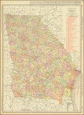
This 1917 Rand McNally New Commercial Atlas Map of Georgia, produced in Chicago, presents a comprehensive view of the state's geography prior to the establishment of Atkinson County. Notable features include the delineation of cities, counties, rivers, and, significantly, the railroads that crisscrossed the state during a pivotal time in Georgia's growth and development.
The late 19th and early 20th centuries were periods of notable expansion in the United States, both in terms of population growth and the growth of infrastructure, such as railroads. This was particularly evident in Georgia, where the railroad industry was a major driver of economic development. The growth of the railroad network facilitated the transport of goods and people, contributing significantly to the expansion of cities and towns across the state.
Detailing the state's counties in distinct colors, this map delivers a clear demarcation of Georgia's political boundaries as they stood in 1917. The impending addition of Atkinson County, founded in August 1917, underscores the continued evolution of Georgia's political geography during this era.
The map's detailed list of Georgia's railroads captures the extensive rail network that defined the state's landscape. From the Alabama Great Southern to the Western Railway of Alabama, this list offers a tangible testament to the scale and scope of the state's rail infrastructure, reflecting the significant role of these railroads in the state's commerce and development during the early 20th century.
Rand McNally & Co. is a large American map and navigation company best known for its annual atlases. The company got its start in 1856, when William Rand opened a print shop in Chicago. He was joined in 1858 by a new employee, Andrew McNally. Together, the men established their namesake company in 1868. Originally, the company was intended to print the tickets and timetables for the trains running to and through Chicago; their first railway guide was published in 1869.
By 1870, they had shifted from just printing to publishing directories, travel guides, and newspapers. Their first map appeared in 1872 in a railway guide. The map was produced using a new wax engraving method, a cheaper process that gave the company an edge.
By 1880 Rand McNally had entered the education market with globes, wall maps, and geography texts for students. In 1923, Rand McNally published the first Goode’s World Atlas, named after its editor, Dr. J. Paul Goode. For generations afterward, this would be the standard classroom atlas.
In 1899, William Rand left the company, but McNally and his family remained, controlling the company for over a century. In 1904, they published their first road map intended for automobiles and by 1907 were publishing Photo-Auto Guides, which combined photography and mapping to help drivers. In 1924, they produced the Auto Chum, a precursor to their famous road atlases. Rand McNally would remain the leader in road maps and atlases throughout the twentieth century.
In 1937, Rand McNally opened its first store in New York City. Ever on the frontier of technology, Rand McNally pioneered the scribing process for printing tickets in 1958 and printed their first full-color road atlas in 1960. Arthur Robinson developed his now-famous projection of Rand McNally in 1969. By the 1980s, the company was exploring digital reproduction and digital databases of maps for truckers. In the 1990s, they lead the charge to develop trip-planning software and websites. Today, most of its products are available online or in a digital format, including maps for tablets and phones.
![(Florida-Georgia) Wie der Franzosen Oberster eine Seul / daran das Wapen dess Königes auss Franckreich / aussrichten lassen. [How the French commander had a seal made, on which the coat of arms of the King of France is displayed.]](https://storage.googleapis.com/raremaps/img/small/95828.jpg)
![The City of Savannah Georgia [with] The City of Charleston South Carolina](https://storage.googleapis.com/raremaps/img/small/71779.jpg)