|
||

|

|
|

|
A visually captivating and informative cartographic treasure from the 1970s, this Lake Tahoe North Shore street index, business directory, and recreation guide provides a vivid snapshot of the region's cultural and commercial landscape during a vibrant period in its history.
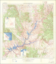
Created circa 1975 by cartographer Bill Andrews, with the support of the California Department of Public Works Division of Highways, this double-sided map offers an engaging blend of the practical and the whimsical. On one side, a vibrant pictorial map of Lake Tahoe's North Shore showcases various businesses and attractions, surrounded by local advertisements. The art for this map was skillfully executed by Fritz Alseth, further contributing to its distinct visual appeal. The verso, on the other hand, presents a more utilitarian layout, featuring a street index, a list of businesses at the Village Shopping Center, an Outside Area Merchants Directory, and a traditional map of the area, complete with inset maps of Incline Village and Tahoe Pines/Homewood.
In addition to serving as a practical guide for visitors and residents alike, the map also reflects the growth and development of Lake Tahoe's North Shore during the 1970s, a period marked by increased tourism, real estate expansion, and the emergence of a thriving recreation industry. The juxtaposition of the practical and the playful on the map demonstrates the dual nature of Lake Tahoe as both a bustling commercial hub and a scenic retreat for leisure and recreation.
This rare map, with no other known examples traced, offers an invaluable window into the Lake Tahoe North Shore's mid-20th century history and its continued evolution. Rich in both artistic and historical significance, it stands as a testament to the ingenuity and creativity of its creators, as well as the vibrant and ever-changing community it so vividly captures.
![(Ontario, California) [Guasti] Water Supply at Cucamonga Station](https://storage.googleapis.com/raremaps/img/small/30028.jpg)