|
||

|

|
|

|
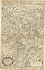
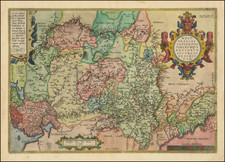
Tracking The Rhine River
Nice Alexis Hubert Jaillot's large map of the Rhine River Valley from the Strassbourg area to Cleve and Duisburg.
The map includes Cologne, Bonn, Coblentz, Mainz, Worms, Manheim, Nuremberg, Strassbourg and Baden. Frankfurt on the Main River is also shown.
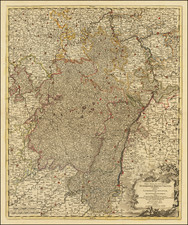
Detailed map of the course of the Rhine through the area of the three bishoprics of Mainz, Cologne, Trier and the Electoral Palatinate. The area shown extends from the Moselle in the west to Wertheim in the east. Includes 4 decorative coats of arms in the title cartouche.
Alexis-Hubert Jaillot (ca. 1632-1712) was one of the most important French cartographers of the seventeenth century. Jaillot traveled to Paris with his brother, Simon, in 1657, hoping to take advantage of Louis XIV's call to the artists and scientists of France to settle and work in Paris. Originally a sculptor, he married the daughter of Nicholas Berey, Jeanne Berey, in 1664, and went into partnership with Nicholas Sanson's sons. Beginning in 1669, he re-engraved and often enlarged many of Sanson's maps, filling in the gap left by the destruction of the Blaeu's printing establishment in 1672.