


|
||

|

|
|

|
Stock# 93972
Description
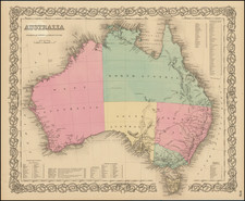
Nice detailed map of Australia, New Zealand, and neighboring islands, with a large inset of the Torres Strait from Blackie & Son's The Comprehensive Atlas & Geography Of The World.
On the Arnhem Coast, Port Essington & Victoria is marked as an abandoned settlement. In the Torres Strait, where soundings are shown, Prince of Wales Island (or Muralag) is labeled Cook Island. Commander John Clements Wickham had given it the name, the largest of the Prince of Wales Islands on his 1839 journey on the HMS Beagle, but the name was not officially adopted. It also appears with this appellation in maps of Australia by O.W. Gray, Johnson, and J.H. Colton.
Condition Description
Minor foxing. Minor soiling in mid-right margin and a nick at right edge.
Reference
Jack, Robert Logan. Northmost Australia. Czechia: Good Press, 2021.

![[Melbourne, Australia] We show you Melbourne City, but from a dizzy height. Come see it as we know it, you'll vote it very bright!](https://storage.googleapis.com/raremaps/img/small/94298.jpg)
![[Australia, Phiippines, New Zealand, Hawaii] Oceanica 1828](https://storage.googleapis.com/raremaps/img/small/61780.jpg)