|
||

|

|
|

|
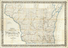
This 1893 Rand McNally map of Wisconsin serves as a detailed snapshot of the state's geographical and political landscape on the cusp of significant changes. Published in Chicago, this document captures the region prior to the establishment of Iron County, providing a unique perspective on Wisconsin's evolution.
The 1893 Rand McNally map situates itself in a crucial period in Wisconsin's history, during the last decade of the 19th century. The state was undergoing rapid industrialization and urbanization, with an influx of immigrants and an expanding railway system. At this time, Wisconsin's lumber and dairy industries were growing exponentially, significantly shaping its economy and land use.
This map, rich in detail, offers a clear depiction of Wisconsin’s counties, towns, rail networks, and key geographical features as they existed at that time. The absence of Iron County, which would soon emerge in 1893 as a result of the region's burgeoning iron ore mining industry, underscores the map’s historical significance.
The Rand McNally Company, founded in 1856, was renowned for its meticulous accuracy and innovative printing methods. The company played an instrumental role in standardizing cartography in the United States during the latter half of the 19th century. This 1893 Wisconsin map exemplifies the company’s commitment to providing up-to-date, reliable cartographic information to the public.
Rand McNally & Co. is a large American map and navigation company best known for its annual atlases. The company got its start in 1856, when William Rand opened a print shop in Chicago. He was joined in 1858 by a new employee, Andrew McNally. Together, the men established their namesake company in 1868. Originally, the company was intended to print the tickets and timetables for the trains running to and through Chicago; their first railway guide was published in 1869.
By 1870, they had shifted from just printing to publishing directories, travel guides, and newspapers. Their first map appeared in 1872 in a railway guide. The map was produced using a new wax engraving method, a cheaper process that gave the company an edge.
By 1880 Rand McNally had entered the education market with globes, wall maps, and geography texts for students. In 1923, Rand McNally published the first Goode’s World Atlas, named after its editor, Dr. J. Paul Goode. For generations afterward, this would be the standard classroom atlas.
In 1899, William Rand left the company, but McNally and his family remained, controlling the company for over a century. In 1904, they published their first road map intended for automobiles and by 1907 were publishing Photo-Auto Guides, which combined photography and mapping to help drivers. In 1924, they produced the Auto Chum, a precursor to their famous road atlases. Rand McNally would remain the leader in road maps and atlases throughout the twentieth century.
In 1937, Rand McNally opened its first store in New York City. Ever on the frontier of technology, Rand McNally pioneered the scribing process for printing tickets in 1958 and printed their first full-color road atlas in 1960. Arthur Robinson developed his now-famous projection of Rand McNally in 1969. By the 1980s, the company was exploring digital reproduction and digital databases of maps for truckers. In the 1990s, they lead the charge to develop trip-planning software and websites. Today, most of its products are available online or in a digital format, including maps for tablets and phones.
![[ Great Lakes - Upper Midwest -- Western Canada ] Partie Occidentale Du Canada, contenant les cinq Grands Lacs, avec Pays Circonvoisons](https://storage.googleapis.com/raremaps/img/small/98377.jpg)
![[Volk Field Air National Guard Base] Map Showing the Vicinity of Camp Douglas, Juneau Co., Wis.](https://storage.googleapis.com/raremaps/img/small/83882.jpg)