|
||

|

|
|

|
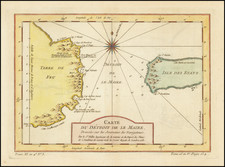
18th Century Manuscript Reconnaissance Chart of the Strait of Magellan in the Year Prior to Bougainville's Charting of the Strait
Well constructed manuscript reconnaissance chart of the eastern portion of the Strait of Magellan, drawn in conjunction with the explorations of the Strait by Lieutenants Nicolas Pierre Duclos-Guyot and François Chenard de la Giraudais, during an expedition from the Falkland Islands to the Straits of Magellan in May-June 1766.
The map is oriented with east at the top (and the word ouest at the bottom left). It is drawn with pen and ink and further augmented with corrections in a contemporary hand with topographical features in pencil, drawn on paper watermarked 1749.
In 1763, Bougainville embarked on an expedition from France aboard the frigate L'Aigle, captained by Duclos-Guyot, and the sloop Le Sphinz, captained by de la Giraudais. Accompanied by naturalist and writer Antoine-Joseph Pernety, they formally took possession of the Falklands in April 1764. Bougainville visited the Strait for the first time in 1765 and then returned to Europe, during which time Duclos-Guyot and de la Giraudais made a second trip to the Straits.
The chart seems to have been made to complement the journals of Guyot-Duclos and De La Giraudais during their exploration of the Straits of Magellan in May and June of 1766. Their journey took place aboard the Aigle and L'Etoile, just before Bougainville's return to the region for the French circumnavigation of the globe (1766-1769). Excerpts of the journals of Duclos and de la Giraudais were first published in 1771 by Antoine-Joseph Pernety, in his Examen des Recherches philosophiques sur l'Amérique et les Américains, et de la Défense de cet ouvrage . . . and translated to English in 1773.
The chart provides a fascinating comparison with the chart attributed to Bougainville's official mapmaker, Charles Routier de Romainville covering the Straits of Magellan, which survives in the BnF collection. Romainville's chart notes that it was made and corrected from the voyages of the Aigle in 1765, the Etoile and Aigle in 1766 and the Boudense and Etoile in 1767 and 1768. A comparison of the two charts strongly points to the present chart being a pre-cursor to the Routier de Romainville's 1768 chart in the BnF.
The following comparison lends strong evidence to the primacy of the current chart and its connection to the 1766 visit of Guyot-Duclos and De la Giraudais:
- B. Duclos on Romainville's chart corresponds to the "Baye Reconoitre" explored by the pair in 1766 and named on the present manuscript map.
- The absence of place names on the southern Tierra del Fuego coast corresponds with Guyot-Duclos and de la Giraudais notes that they did not explore this coast.
- The conflation of "Cap Bandre" which is struck over and corrected to Cap Hollandais in pencil, corresponds to the corrected locations of Cap Hollandais and B. Andre on the Romainville chart.
- Both maps note the point where the pair began encountering woods.
- The journals both make observations about the heights of native Patagonians encountered.
The annotations are all in French, and the long note at the bottom states that the inhabitants of the mountains are taller than those at Cape Froward. There are two other annotations referring to the size of the Patagonians, one saying that they are quite small, the other the opposite.
From the English translation of journal of Lieutenant Guyot-Duclos found in History of a Voyage to the Malouine (or Falkland Islands) . . . , Volume II, p. 270-294 (1773), we find the following passages, which corresponds with the notes on the map:
Entering The Strait
On Sunday the 4th [of May] . . . we were about four leagues S.E. of Cape Possession. There is a ridge of rocks and a sand bank [Batture on our map] near Cape Orange. It extends a great way, so we were obliged to coast the land of [Terre des] Patagonia
First encounter with woods at Cap Noir
On Friday the ninth we set sail at day-break. At ten o'clock we got into the second narrows, and steered our course in order to pass between the islands of St. Elizabeth and St. Bartholomew. We afterwards anchored at 11 o'clock in the bay of Cape Noir, its point being N. N. W. 5 degrees N. where the wood begins to appear.
From the journal of Lieutenant De La Giraudais (History of a Voyage . . . ), we find additional corroborations:
Baye Reconnoitre
From the 10th and the 11th, we had much wind, and foggy weather, with a very rough sea. As we were no more than five leagues from Port Famine, I determined to go to anchor there. The Eagle followed us . . .
From the 11th to the 12th, the fog and rainy weather continued. Having walked round the bay, we met with some fine wood, and discovered a very rapid river . . .
It would not be until the following year in 1767 that Bougainville himself would re-enter the Straits on his circumnavigation. The details from Bougainville's account do not correlate well with the present map. It would seem far more likely, therefore, that the present map was drawn by Guyot-Duclos, de la Giraudais, or someone who accompanied there 1766 expedition into the Straits, and that this expedition furnished the information referenced by Romainville in the title of the manuscript map at the BnF.
Translations of French Annotations:
- The savages living in these mountains are bigger and taller than the ones living at the cap (most likely Cap Horn) and they have pirogues made of small trees to navigate from one bay to another....
- The Patagonian savages that live in these lands are big and tall
- ??? saw the....................located by the latitude 53 degrees and 49 degrees???????? and few seconds, and all the mountains that follow are covered with snow on their tops and all the rest is covered with trees and forests.
![(Argentine Antarctic Territory) Republica Argentina Territorio Nacional de la Tierra del Fuego e Islas del Atlantico Sur [Argentine Republic, National Territory of Tierra del Fuego, Antarctica, and South Atlantic Islands.]](https://storage.googleapis.com/raremaps/img/small/94971.jpg)