|
||

|

|
|

|
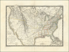
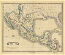
First Appearance of Austin's Settlement In Texas
Nice example of the 1827 edition of Amos Lay's wall map of the United States, first published in May of 1827, the earliest obtainable printed map to include Austin's Settlement and the earliest map of the United States to emphasize Indian Settlements as distinct geographical regions.
The present example is the second state of the 1827 edition. The first state is apparently only known in a single example. A comparison of the two states is given below.
Lay's map is unique in that it shows an outline coloring for the major Sovereign Indian regions of the United States, including those in Missouri, Georgia, Mississippi, Alabama and Arkansas. The reservations are also delineated in Michigan, Illinois, and Indiana. West of the Mississippi River, a number of early Native American settlements are shown on the major rivers.
Carver's Indian Grant is noted in North West Territory, with a massive Missouri Territory to the west, crossed only by the "Route of the Traders from Missouri to New Mexico." Further West in Arkansas Territory, Stephen Long's route to the Rocky Mountains along the South Fork is shown, as is Captain Bell's detachment from the Long Expedition, which following the south Fork of the Canadian River to the Rocky Mountains.
Streeter noted that the 1827 edition of the map is the earliest appearance of Austin's Settlement on a printed map, with the exception of a rare Mexico City imprint (the Galli Map), known in only one example. Streeter notes that the settlement, likely intended to be San Felipe de Austin, is incorrectly shown on the east bank of the Colorado River. The mythical Presidio of Nacogdoches is shown, not far from the coast between Galveston Bay and the Sabine River. St. Louis Bay is shown at the mouth of the Brazos.
Includes a large inset map of Florida, including the route of a proposed Atlantic to Gulf Coast canal from Pilatkia, south of St. Augustine on the St. Mary's River to the Tampa River and Espiritu Santo Bay.
States of the Map
Streeter notes the existence of the 1827 and 1830 editions. To this, we can add an 1829 edition, which we handled in 2015, and an 1832 edition.
We note that there are at least 2 states of the 1827 edition of the map.
- State 1: Hudson's Bay Company Territory not yet shown. Lacks topographical detail in Michigan Territory and North West Territory, which includes a note "Attached to Michigan Territory."
- State 2: Hudson's Bay Company Territory named north of Lake Superior. Carver's Indian Purchase shown. Significant new topographical detail in Michigan Territory and North West Territory, which includes a note "Attached to Michigan Territory." Canadian Company lands shown south of Lake Huron. Significant revisions to Northern Florida, including Alachua Grant, 2 proposed canals , numerous rivers and lakes. Canada Province line added.
Rarity
The Lay map is scarce on the market.
![[Shows Republic of Texas] United States and Texas](https://storage.googleapis.com/raremaps/img/small/101139.jpg)