This item has been sold, but you can enter your email address to be notified if another example becomes available.


|
||

|

|
|

|
Stock# 9378
Description
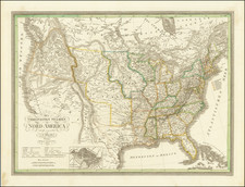
A gorgeous example of Flemming'smap of the United States, exhibiting in fabulous detail the early US territorial borders, Indian Districts, Forts, early routes of the Transmississippi explorers and other details. many Indian tribes, forts, missions, roads, and other details. Too much good material to mention. Includes a very unusual tomahawk shaped Indian Territory and massive Minnesotah and Missouri Territories. Excellent topographical details, some real, some conjecture. Pre-Gadsden Purchase atlas map, which predates the split of Oregon Territory into Oregon and Washington, but shows both Utah and New Mexico, inducating that it was issued sometime around 1850. A marvelous territorial map.
![Colton's United States Shewing Military Stations, Forts &c. . . . 1861 [Shows Colorada!]](https://storage.googleapis.com/raremaps/img/small/95088.jpg)
![United States History-Map (Five historical maps, including Toscanelli's Map of 1474) [Cover title:] Bacon's Excelsior Wall Atlases - America](https://storage.googleapis.com/raremaps/img/small/88839.jpg)
![[ English Plantations in North America ] A New Map of the most Considerable Plantations of the English In America Dedicated to His Highness William Duke of Glocester.](https://storage.googleapis.com/raremaps/img/small/98233.jpg)