


|
||

|

|
|

|
Not in McLaughlin
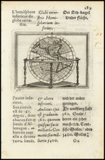
The engraved page titled "Saeculum Nostrum in Illuminatione Vultus Tui Psal 89" is a beautiful artifact that elegantly fuses religious symbolism, geography, and allegory.
The title, referring to Psalm 89, suggests the theme of enduring covenant and divine favor, which sets a contemplative backdrop to the illustration and resonates with the Jesuits' self-perception as bearers of the Christian faith to the New World.
At the very top of the page, the IHS symbol, a monogram denoting the Greek spelling of Jesus, is prominently placed, marking the work with the Jesuits' spiritual dedication. On either side, the images of a crab and a lion are inscribed, astrological signs for Cancer and Leo.
The main image on the page is a captivating depiction of two women embracing a globe, highlighting the Americas. The globe, detailed and proportioned, shows a majority of North America, Central America, and the northern part of South America. Interestingly, California is represented as an island, a common cartographic misinterpretation of the period. The embracing women, likely allegorical figures, might symbolize virtues or guiding principles of the Jesuits, their postures embodying both protection and guidance over these lands.
Below the central image, a Latin inscription reads: "Fulsit in ignatio tam centum hoc nomen in annos: terra fave; melior sol hic, et ille leo est, ferte sub hoc, divae, dum totum illuminet, orbem: plus cobis, orbi plus quoque lucis erit." The loose translation of this would be: "This name has shone in Ignatius for so many hundred years: Favor the earth; a better sun is here, and he is the lion, carry under this, goddesses, while he illuminates the whole world: there will be more light for us, and also more for the world." This inscription emphasizes the Jesuits' dedication to spreading enlightenment and their view of their mission as a divine directive.
Overall, this engraved page is a striking piece of Jesuit iconography that melds the spiritual, the allegorical, and the geographical into a testament to the order's commitment to its mission in the Americas during the Age of Discovery.
Rarity
This is the first time we have seen this image, which is not noted in McLaughin's book on the mapping of California as an Island.
The popular misconception of California as an island can be found on European maps from the sixteenth through the eighteenth centuries. From its first portrayal on a printed map by Diego Gutiérrez, in 1562, California was shown as part of North America by mapmakers, including Gerardus Mercator and Abraham Ortelius. In the 1620s, however, it began to appear as an island in several sources. While most of these show the equivalent of the modern state of California separated from the continent, others, like a manuscript chart by Joao Teixeira Albernaz I (ca. 1632) now in the collection of the National Library of Brasil shows the entire western half of North Americas as an island.
The myth of California as an island was most likely the result of the travel account of Sebastian Vizcaino, who had been sent north up the shore of California in 1602. A Carmelite friar, Fray Antonio de la Ascensión, accompanied him. Ascension described the land as an island and around 1620 sketched maps to that effect. Normally, this information would have been reviewed and locked in the Spanish repository, the Casa de la Contratación. However, the manuscript maps were intercepted in the Atlantic by the Dutch, who took them to Amsterdam where they began to circulate. Ascensión also published descriptions of the insular geography in Juan Torquemada’s Monarquia Indiana (1613) (with the island details curtailed somewhat) and in his own Relación breve of ca. 1620.
The first known maps to show California as an island were on the title pages of Antonio de Herrera’s Descripción de las Indias Occidentales (1622) and Jacob le Maire's Spieghel Der Australische Navigatie (1622). Two early examples of larger maps are those by Abraham Goos (1624) and another by Henry Briggs, which was included in Samuel Purchas’ Hakluytus Posthumus or Purchas his Pilgrimes (1625). In addition to Briggs and Goos, prominent practitioners like Jan Jansson and Nicolas Sanson adopted the new island and the practice became commonplace. John Speed’s map (1626-7), based on Briggs’ work, is well known for being one of the first to depict an insular California.
The island of California became a fixture on mid- and late-seventeenth century maps. The island suggested possible links to the Northwest Passage, with rivers in the North American interior supposedly connecting to the sea between California and the mainland. Furthermore, Francis Drake had landed in northern California on his circumnavigation (1577-80) and an insular California suggested that Spanish power in the area could be questioned.
Not everyone was convinced, however. Father Eusebio Kino, after extensive travels in what is now California, Arizona, and northern Mexico concluded that the island was actually a peninsula and published a map refuting the claim (Paris, 1705). Another skeptic was Guillaume De L’Isle. In 1700, De L’Isle discussed “whether California is an Island or a part of the continent” with J. D. Cassini; the letter was published in 1715. After reviewing all the literature available to him in Paris, De L’Isle concluded that the evidence supporting an insular California was not trustworthy. He also cited more recent explorations by the Jesuits (including Kino) that disproved the island theory. Later, in his map of 1722 (Carte d’Amerique dressee pour l’usage du Roy), De L’Isle would abandon the island theory entirely.
Despite Kino’s and De L’Isle’s work, California as an island remained common on maps until the mid-eighteenth century. De L’Isle’s son-in-law, Philippe Buache, for example, remained an adherent of the island depiction for some time. Another believer was Herman Moll, who reported that California was unequivocally an island, for he had had sailors in his offices that claimed to have circumnavigated it. In the face of such skepticism, the King of Spain, Ferdinand VII, had to issue a decree in 1747 proclaiming California to be a peninsula connected to North America; the geographic chimera, no matter how appealing, was not to be suffered any longer, although a few final maps were printed with the lingering island.
![Сны Султана (Картина 2) [Dreams of the Sultan. Scene 2]](https://storage.googleapis.com/raremaps/img/small/60238.jpg)
![[Pictish Man Holding Sword and Pike] Alterius viri Pictis vicini icon IIII](https://storage.googleapis.com/raremaps/img/small/99890.jpg)