|
||

|

|
|

|
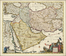
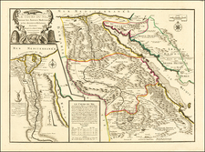
Fine Map of the Ottoman Empire from the Cloppenburg Edition of the Mercator-Hondius Atlas Minor
Striking example of this map of the Ottoman Empire, showing their territories in the Balkans, Anatolia, the Levant, the Arabian Peninsula, and North Africa.
The border of the Ottoman Empire was one of the largest land empires in history. Cities and towns are labeled, with the largest cities marked with the characteristic small building symbol that was used throughout the atlas. Mountains and hills are included, especially on the Arabian Peninsula.
A handsome strapwork cartouche holds the title and scale in the lower left corner.
One of Hondius’ most successful commercial ventures was the reprinting of Mercator’s atlas. Gerard Mercator died in 1594 without having completed his most ambitious project, an atlas of the entire world. His son and grandsons completed the work and released its final volume in 1595.
The younger Mercators released another edition in 1602, but they then sold the plates to Jodocus Hondius the Elder in 1604. Hondius published his first edition in 1606; there were roughly fifty editions in various European languages in the seventeenth century.
Hondius died in 1612, at only 48 years of age, after which time his son of the same name and his other son, Henricus, took over the business, including the reissuing of the Mercator atlas. After 1633, Hondius the Elder’s son-in-law, Johannes Janssonius, was also listed as a co-publisher for the atlas.
The Ottoman Empire spanned three continents and six centuries. At its height, it stretched from the gates of Vienna, across Hungary, the Balkans, Greece, parts of Ukraine, much of the Middle East, and North Africa west to Algeria.
The empire was founded by Osman I, a nomadic Turkmen leader from whose name the word Ottoman is derived, in ca. 1300. Until 1481, the Ottoman Empire almost continually expanded. In 1453, their forces captured Constantinople, renaming it Istanbul and ending the millennium-old Byzantine Empire. By 1517, they had control over Syria, Arabia, Palestine, and Egypt. The peak of the empire came under Suleiman the Magnificent, in the mid-sixteenth century, when most of Eastern Europe was added to their domains.
Suleiman also oversaw the creation of a uniform system of law and ruled during a flourishing of the arts. Ottoman scholars were leaders in mathematics, astronomy, philosophy, geography, and other fields. As just one example, in medicine, they invented forceps, catheters, scalpels, pincers, and lancets.
From the fourteenth to the seventeenth centuries, the devshirme system helped to provide trained statemen and officials to the expanding polity. Christians were required to give up twenty percent of their children to the state. These men converted to Islam and were classified as slaves. This status did not prevent them from gaining wealth and power; those who worked for the government and military ascended to the highest echelons of their professions. The Janissaries, the Ottoman’s elite military unit, were largely made up of these forced converts.
Despite these forced conversions, many scholars characterize the Ottoman Empire as one of regional stability and relative tolerance. As they spread, the Ottomans found themselves ruling over a diverse array of peoples with different customs, religions, and languages. Rather than widespread conversion and assimilation, the Ottomans allowed people to maintain their customs and languages. Major religious groups were allowed to create millets, or limited self-governing communities that were protected by the sultan. Some millets paid taxes, while others were exempt.
From the seventeenth century, the Ottoman Empire began to contract, although it was still a dynamic and innovative political and social body during the subsequent centuries. They were defeated at the Battle of Vienna in 1683. In 1830, Greece won its independence, while in 1878, the Congress of Berlin declared Romania, Serbia, and Bulgaria independent. By the end of WWI, the Ottoman Empire was disbanded, with territories split between the Allied powers. Anatolia, the heart of the Ottoman Empire, became the Republic of Turkey in 1923.
Johannes Cloppenburg (sometimes Cloppenburgh; also H. Jan Evertsz and Johannes Everhardus) was a Dutch cartographer. Based in Amsterdam, he was active between roughly 1610 and 1644. He worked closely with the Hondius/Jansson firm and is credited with the 1630 edition of the Atlas Minor.