|
||

|

|
|

|
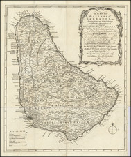
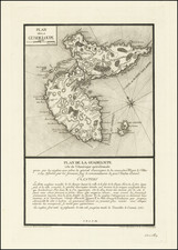
One of the Earliest Obtainable Maps of St. Kitts
Nice full color example of the first printed map of St. Kitts.
Mariette's map is the first to show the island of St Kitts (formally St Christophers) as divided between the English and French colonists, the first Caribbean island colonized by each of these two European powers.
The English colony on St. Christopher was founded by the English captain Thomas Warner in 1623, having retreated from an attempt to colonize Guiana. Two years later Warner allowed a French ship, sole survivor of a Spanish attack on a colonist's fleet, to also settle on the island. The two groups of Colonists would later organize a joint attack wherein the Colonists massacred the indigenous Kalinago tribe, after which the island was formally divided in 1626.
Mariette's map was produced at a time when the geopolitical landscape of the Caribbean was undergoing significant changes. The 17th century marked an era of intense colonial competition between the European powers, with the fertile and strategically placed St. Kitts being a prized possession. It was during this period that the island, originally inhabited by the Kalinago people, found itself at the center of Franco-British rivalry, their competing claims leading to a unique, albeit tense, dual settlement.
Mariette's map captures this shared colonial history, depicting the division of the island between the French and British, with the French controlling the north and south parts of the island and the British the center. The detailed delineations of the territory, including geographical features, anchorites, forts and several settlements.
Shortly after this map was created, French troops took the whole island in 1665, only for the status quo to be restored by the Treaty of Breda in 1667. In 1689 the French took over again, destroying English farms. In retaliation General Codrington defeated the French army and deported all the French to Martinique, only for them to return under the terms of the Treaty of Rijswijk in 1697. The Treaty of Utrecht (1713) finally gave the British total control of the island.
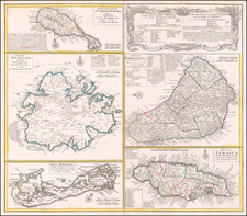
![[Hispaniola, Cuba, Martinique and Guadalupe] Carte de S.Domingue . . . / Carte de Cuba . . . / Carte de Martinique . . . / Carte de Guadalupe et des Isles de Saintes . .](https://storage.googleapis.com/raremaps/img/small/70543.jpg)