|
||

|

|
|

|
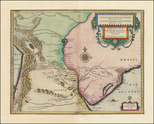
An Early Golden Age Depiction of the Le Maire Strait and Adjacent Strait of Magellan
Fascinating representation of the early exploration of South America's southern tip, titled "Du Destroit de Magellan" from the Mercator Hondius Atlas Minor, showing the iconic Strait of Magellan and Le Maire Strait, critical milestones in the history of maritime exploration.
The map is not only rich in detail, but it also is aesthetically pleasing, featuring rhumb lines and a prominent compass rose at the center. The rhumb lines serve both a practical and aesthetic purpose, illustrating lines of constant bearing that are invaluable for navigation, while also embellishing the map with a sense of antiquity. The compass rose serves as the centerpiece, a tribute to the remote seas and treacherous waters surrounding the Straits.
The map depicts Staten Lant (Staten Landt) and the Le Maire Strait, both significant geographical features linked to early Dutch exploration. Jacob Le Maire and Willem Schouten, Dutch explorers, discovered the Le Maire Strait in 1616 during their quest for a new route to the Pacific, challenging the monopoly held by the Strait of Magellan. This discovery is documented on the map shortly after its occurrence, marking a significant advancement in early 17th-century maritime knowledge.
The Strait of Magellan itself, named after the Portuguese explorer Ferdinand Magellan, is shown in remarkable detail. Magellan first navigated these treacherous waters in 1520 during his famous circumnavigation of the globe, providing the first viable sea route connecting the Atlantic and Pacific Oceans. This discovery, transformative for world trade and exploration, remains a testament to human determination and ingenuity.
Numerous place names are meticulously documented in Dutch, providing a cultural and historical snapshot of the period. These annotations, reminiscent of the Dutch Golden Age's cartographic prowess, give us unique insights into the place names as understood and recorded during that era.
Johannes Cloppenburg (sometimes Cloppenburgh; also H. Jan Evertsz and Johannes Everhardus) was a Dutch cartographer. Based in Amsterdam, he was active between roughly 1610 and 1644. He worked closely with the Hondius/Jansson firm and is credited with the 1630 edition of the Atlas Minor.
Gerard Mercator is one of the most famous cartographers of all time. Mercator was born in Flanders and educated at the Catholic University in Leuven. After his graduation in 1532, Mercator worked with Gemma Frisius, a prominent mathematician, and Gaspar a Myrica, a goldsmith and engraver. Together, these men produced globes and scientific instruments, allowing Mercator to hone his skills.
With his wife, Barbara, Mercator had six children: Arnold, Emerentia, Dorothes, Bartholomeus, Rumold, and Catharina. In 1552, Mercator moved to Duisburg from Leuven, where he lived for the rest of his life. In 1564, he was appointed the official cosmographer to the court of Duke Wilhelm of Cleve.
Mercator’s most important contribution was the creation and popularization of a projection which now bears his name. On Mercator projection maps, all parallels and meridians are drawn at right angles to each other, with the distance between the parallels extending towards the poles. This allowed for accurate latitude and longitude calculation and also allowed navigational routes to be drawn using straight lines, a huge advantage for sailors as this allowed them to plot courses without constant recourse to adjusting compass readings.
Mercator’s other enduring contribution to cartography is the term “atlas”, which was first used to describe his collection of maps gathered in one volume. The Mercator atlas was published in 1595, a year after Mercator’s death, thanks to the work of his sons, particularly Rumold, and his grandsons.

![[ Chile ] Chili](https://storage.googleapis.com/raremaps/img/small/97228.jpg)