|
||

|

|
|

|
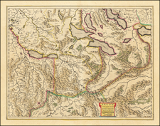
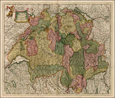
Pierre Du Val's map of Switzerland, crafted and published in Paris in the late 17th century, is a remarkably detailed testament to the richness and diversity of Swiss geography and heritage. This masterful representation exhibits an astute blend of cartographic precision, ornamental details, and insightful commentary on the geopolitical landscape of Switzerland during this period.
A notable feature of Du Val's map is the inclusion of the coats-of-arms of the 13 Swiss Cantons at the left margin. These heraldic symbols lend the map an element of historical and cultural depth, representing the distinctive identities and histories of each canton. Running across the top of the map are the names and founding dates of each of Switzerland's 13 Cantons.
At the right side of the map, we find the coats of arms of "Les Allies des Cantons Suisses," which translates to "The Allies of the Swiss Cantons." These symbols represent the various city-states, regions, and powers associated with the Swiss Cantons, illuminating the diplomatic and political alliances that shaped Switzerland's history and its standing in the broader European context during the late 17th century.
Along the bottom of the map, Du Val presents the viewer with seven coats of arms, accompanied by the names of "les pais sujets cantons" or "the subject lands of the cantons." These represent territories under the jurisdiction of the Swiss cantons, highlighting the influence and reach of the Swiss Confederation during this period.
The map itself is a study in the stunning topography of Switzerland. The terrain is depicted with a sophisticated level of detail, underscoring the diverse geography of this central European nation. The cartographer's meticulous hand captures the sprawling plains, picturesque valleys, majestic mountains, intricate river systems, and expansive lakes, immersing the viewer in the natural beauty of Switzerland. Prominent landmarks, such as the Alps, are depicted with a skillful touch, emphasizing their grandeur and significance.
Pierre Du Val's map of Switzerland is a unique combination of geography, heraldry, and history. It invites viewers to explore the contours of the Swiss Confederation's physical landscape while simultaneously revealing the complex tapestry of political and historical narratives that shaped this resilient nation.
Pierre Duval (1618-1683) was a French geographer, cartographer, and publisher who worked in Abbeville and Paris during the seventeenth century. He was born in the former city, in northeast France, before moving to Paris. Duval was the nephew of the famous cartographer Nicolas Sanson, from whom he learned the mapmaker's art and skills. Both men worked at the royal court, having followed the royal request for artists to relocate to Paris. In addition to numerous maps and atlases, Du Val's opus also includes geography texts. He held the title of geographe ordinaire du roi from 1650 and died in 1683, when his wife and daughters took over his business.