


|
||

|

|
|

|
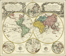
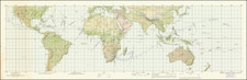
Decorative double hemisphere map of the world, with four additional hemispheric maps and two celestial models.
Compiled by J.M. Haas, Professor of Mathematics at Wittenberg, this double hemisphere map of the world is a captivating blend of cartographic precision, historical insights, and artistic embellishments.
One of the map's most fascinating aspects is its depiction of Australia and New Zealand, both represented incompletely, indicative of the nascent state of exploration in the Southern Hemisphere during this period. This predates the voyages of Captain James Cook and thus provides a unique insight into the speculative geographies that characterized early representations of these regions.
The map is decorated with two elaborate cartouches, adding a layer of artistic grandeur to the already intricate cartographic detail. Four smaller maps display polar projections, offering alternative views of the world and highlighting the North and South Poles' significance in the geographical imagination of the time.
Additionally, the map features two models of the sun illuminating the earth, a nod to contemporary understandings of the solar system and the earth's place within it. These models not only serve a decorative function but also provide a scientific context to the map's geographical portrayals.
The present example has been revised and updated to show the Russian discoveries along the Northwest Coast of America in the 1740s and was likely issued shortly after the reports of Muller and Bellin addressing the Russian discoveries in the region.
The depiction of the Northwestern coast of America in this 1746 double hemisphere map by Homann Heirs is particularly fascinating. These details, quite speculative and not wholly accurate by our modern understanding, owe much to the pioneering Russian explorations of the time, primarily those led by Vitus Bering and Aleksei Chirikov.
In 1725, Peter the Great of Russia commissioned Bering, a Danish explorer in Russian service, to determine whether Asia and North America were connected. This expedition, later known as the First Kamchatka Expedition, provided initial but incomplete information about the region. However, it was Bering's second voyage, known as the Great Northern Expedition from 1733-1743, that provided more substantial details. Aleksei Chirikov, as the second-in-command, played a vital role in this expedition. They set out across the uncharted waters of the North Pacific, mapping significant portions of the far-flung Siberian coast and reaching as far as the western coast of present-day Alaska.
Despite the tragic end of this expedition, with Bering's death and loss of two ships, the voyage provided valuable insights about the Northwestern Coast of America. This map, drawn shortly after these voyages, incorporates some of this early information, presenting a nascent outline of Alaska and the adjacent coasts.
Yet, this map pre-dates the concept of the "Sea of the West," a large, speculative body of water believed to exist in the Pacific Northwest of North America. This sea, as conjectured by many European cartographers during the mid-18th century, would not begin to appear until the 1750s, highlighting the evolving understanding of this region.
Homann Heirs was a German publishing firm that enjoyed a major place in the European map market throughout the eighteenth century. Founded in 1702 by Johann Baptist Homann, the business passed to his son, Christoph, upon Johann’s death in 1724. Christoph died in 1730, aged only 27, and the firm was inherited by subsequent Homann heirs. This altered the name of the company, which was known as Homann Erben, or Homann heirs. The firm continued in business until 1848.

![The Western Hemisphere... [with:] The Eastern Hemisphere A Stereographical Projection on the Twentieth Meridian](https://storage.googleapis.com/raremaps/img/small/97573.jpg)