


|
||

|

|
|

|
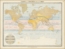
Published in Amsterdam around 1720, the "De Werelt Caart" is a finely engraved double hemisphere map of the world. It was originally produced by Justus Danckerts around 1700 and was later re-issued by Rudolf & Jacob Wetstein and William Smith.
The map offers a fascinating glimpse into the geographic misconceptions of its time. For instance, it depicts California as an island and misplaces the terminus of the Mississippi River far to the west of its actual location in the Gulf of Mexico. It also includes a large land bridge, Terra Esonis, extending from California to Japan.
In terms of the Pacific region, the map shows an early understanding of Australia's coastline, albeit with little detail on the southern and eastern coastlines. Van Diemen's Land (modern-day Tasmania) is well outlined, as is one coastline of New Zealand, reflecting the discoveries of Dutch explorer Abel Tasman. Korea is depicted as a narrow peninsula, and the Philippines appear prominently west of China and the Malay Peninsula.
Interestingly, the map clearly shows a Northeast Passage but does not include a polar passage above North America. Two smaller polar hemispheric projections accompany the main map, along with a model of the Solar System based on Ptolemaic theory and a model of an eclipse.
This map is a valuable piece of historical cartography, showcasing the geographical understanding and misconceptions of the early 18th century. As such, it serves as an important tool for understanding the evolution of global mapping and exploration.
![[Signed Political Satire Artwork] Vietnam ... Vietnam ... Vietnam ...](https://storage.googleapis.com/raremaps/img/small/68726.jpg)
![Apollo Earth Orbit Chart (AEO) Apollo Mission 8. Sheet 1 of 3, Contains Revolution 1. For December 1968 Launch Dates [with:] Sheet 2 of 3, Contains Revolution 2. For December 1968 Launch Dates [and: Sheet 3 of 3, Contains Revolution 3. For December 1968 Launch Dates]](https://storage.googleapis.com/raremaps/img/small/95707.jpg)
![[Mussolini Celebrates Pearl Harbor] Grande Carta Del Pacifico](https://storage.googleapis.com/raremaps/img/small/65273.jpg)
