|
||

|

|
|

|
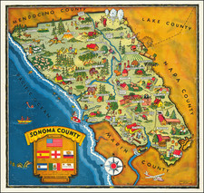
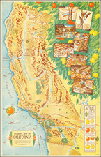
Depression Era Northern California Homesteading Map
Fascinating map of Northwestern California District Number 2 Showing Government Homestead Land in Northern California, published in 1933 by the Empire Map Company of San Francisco.
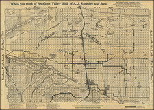
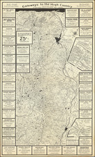
The map itself is a meticulous representation of Northwestern California, centered on Clear Lake and the California National Forest Reserve. Each county and township is delineated with precision, and specific parcels of land are designated as Government Homestead Land, illustrating the areas available for homesteading at the time, along with major roads, railroads, springs, several mines, Lakes, Hospitals and and Insane Asylum south of Ukiah.
The map's primary function was to guide potential homesteaders to government-allocated lands. Homesteading in California during the early 20th century was a period of significant growth and change. The Homestead Act of 1862 provided an avenue for U.S. citizens to claim up to 160 acres of government land, provided they improve it by building a dwelling and growing crops. By the 1930s, the promise of fertile lands and the possibility of owning property lured many people to California.
The homesteaders who migrated to these counties in California were a diverse lot, with many coming from across the United States. A large number came from the Midwest, where the agricultural depression of the 1920s and the Dust Bowl of the 1930s drove many farming families to look for opportunities elsewhere. The West, and California in particular, with its relatively mild climate and vast, underpopulated lands, seemed like a land of promise.
These homesteaders brought with them a mix of cultures and traditions that further enriched the cultural tapestry of the state. They were predominantly of European descent, but there were also a significant number of African American, Hispanic, and Asian homesteaders. The 1930s also saw the influx of "Okies," displaced farmers from Oklahoma and neighboring states escaping the Dust Bowl, who added to the demographic diversity of the region.
The map includes red X's in several areas, including the areas around:
- Hearsts
- Travelers Home
- Willets
- Saratoga Springs
- Blue Lakes
Migration To California During the Depression / Dust Bowl
More people migrated to California in the 1930s than any other state in the country. The constant arrival of poor migrants overwhelmed schools and services in the small farm towns of California.
Of the half million people who fled Oklahoma and neighboring states during the Depression years, more than 300,000 went to California. Most were farmers or tenant farmers, and they came to California in search of farm work.
Rarity
The present map is apparently unrecorded. We find no examples in OCLC or otherwise.
Blueprint & Blue Line maps (Cyanotype Printing)
Blueprint and blue line maps were among the most popular means for the swift printing of maps for which there would be a limited demand. A blueprint or blue line map could be made and/or revised much more quickly than a lithograph, cerograph, or other printing method, and at a much lower cost.
This method of printing was invented in 1842 by John Herschel, a chemist, astronomer, and photographer. A cyanotype process, one starts by drawing on semi-transparent paper, weighted down by a top sheet of paper. The paper would be coated with a photosensitive chemical mixture of potassium ferricyanogen and ferric ammonium citrate. The paper would then be exposed to light, wherein the exposed portions turned blue and the drawn lines, protected from exposure, would remain white.
The cyanotype printing process was an improvement on the expensive and time-consuming method of hand-tracing original documents. The technique was particularly popular with architects; by the 1890s, a blueprint was one-tenth the cost of a hand-traced reproduction. It could also be copied more quickly.
Blueprint and blue line maps began to appear as early as the 1850s and 1860s, but they really began to become the standard for mining and similar limited-purpose maps by the 1880s. The ability to create these maps quickly and at a low cost made them the standard for short-run prints, ideal for mapping mining regions in the West and for similar purposes.
The method still exists today, but in a very limited fashion. In the 1940s, diazo prints (whiteprints or bluelines) became more popular, as they were easier to read and faster to make. The blue lines on a white background of these prints are now what most people call blueprints.