|
||

|

|
|

|
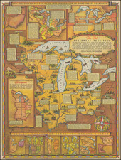
The present map offers a detailed snapshot of the territorial divisions between the indigenous Chippewa tribes and the United States government in Minnesota. This geographical tool, originally serving as a key to a larger wall map, visually encapsulates the historical developments of land cessions by the Chippewa tribes.
The onset of the 20th century was a period of significant transformation for the indigenous tribes of North America. The Chippewa tribes of Minnesota, among others, were continuously pressed by settlers and the U.S. government to relinquish their ancestral lands. This map, with its delineation of ceded territories, testifies to the profound impact of these agreements, offering a nuanced view of this critical period in American history.
The map distinctively outlines various land cessions from different Chippewa bands, such as the Red Lake and Pembina bands, the Bois Forte bands of Superior Chippewas, and the Chippewas of Lake Superior and Mississippi. Each section of land is labeled with the corresponding treaty date, providing a comprehensive timeline of land cessions. Moreover, the map denotes reserved lands like the Red Lake Indian Reservation, White Earth Indian Reservation, and others, accentuating the diminishing territories reserved for these indigenous communities.
This key map stands as an insightful resource into the complicated dynamics between the Chippewa tribes and the U.S. government during the early 20th century. The territories' geographical and historical significance, combined with the diagram's meticulous detailing, render this map an indispensable resource for comprehending the historical context surrounding indigenous land cessions in Minnesota.
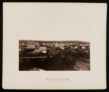
![[ Superior, Wisconsin ] The Next Great City Watch Us Grow Superior](https://storage.googleapis.com/raremaps/img/small/99914.jpg)