|
||

|

|
|

|
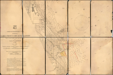
Detailed hand drawn plat map of Cedarville, Indiana, along with Ewing's Addition, northeast of Ft. Wayne, Indiana.
The map seems to have been drawn at a moment in time when the this part of Indiana, including the neighboring city of Fort Wayne and Allen County, was experiencing a period of economic prosperity after the Civil War. This prosperity to In 1869, the Jackson, Fort Wayne & Cincinnati Railroad was seeking $50,000 from Allen County to subsidize one of two prospective railroad lines, on running north from Ft. Wayne (the Stoner Line) and one running northeast from Ft. Wayne (the Cedarville Line). On February 17, 1869, the Fort Wayne Daily Gazette ran an editorial endorsing the Cedarville line. The Cedarville line seems to have prevailed.
The map was apparently drawn prior to June 20, 1871, when Hill's Addition was approved and added to the town plat. On the verso, there is an note as follows:
Mr. Birkholder Presented to
Mr. David Meyers
Mr. & Mrs. Frank Stapleton
A second more faint note appears to read "Minerva Myers Stapleton", who may have relocated to Cederville in 1872. It is possible that Minerva Stapleton was involved in the women's suffrage movement in the late 1860s, and in 1869, she was involved in the reorganization of the Indian Women's suffrage organization when it was re-named Indiana Woman's Suffrage Association (IWSA).
Frank E Stapleton was named postmaster of Cedarville in 1893.
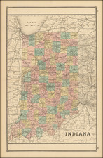
Cedarville, Indiana
Cedarville was being platted in 1838 by the Ewings of Fort Wayne and Cass County Indiana, and a firm of Connecticut prospectors. Situated between the forks of the St. Joseph River and Cedar Creek.
In 1859, Cedarville was incorporated as a town. As the town grew in population it added new sections, including Ewing's Addition, which was approved on October 4th, 1870, John Ewing, a prominent landowner in the area. Another notable addition was the Hill's Addition, which was approved on June 20th, 1871.
The Mill and Dam on Cedar Creek were also important parts of Cedarville's history. The mill was built in the early 1800s and was used for grinding grain into flour. It was a crucial resource for the growing community, as it provided a way for farmers to process their crops into usable products.
The dam on Cedar Creek was built to power the mill. It was a wooden dam that created a pond behind it, which in turn provided the water necessary to turn the mill's grinding stones. The dam was a significant landmark in the area and was an important source of power for the community.