|
||

|

|
|

|
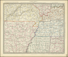
This 1795 map by Mathew Carey offers a wonderfully detailed portrayal of Tennessee territory right on the cusp of its transition from a "government" to a state.
Grounded largely on the survey work of General Daniel Smith, this first state rendition of Carey's Tennessee map takes its place in the annals of early United States mapping.
Embedded within the shifting historical landscape of late 18th-century America, this map manifests the vibrant spirit of exploration, discovery, and frontier settlement. In 1795, the year of the map's publication, Tennessee was poised on the brink of statehood, having just transitioned from a frontier territory to an organized incorporated territory two years prior. Cartographers like Carey played a significant role in this westward expansion, providing settlers and policymakers alike with invaluable geographical information.
This map conveys a wealth of data, reflecting Carey's intent to give a comprehensive view of the Tennessee region. Settlements, roads, trails, and Indian boundaries are clearly marked, along with the intriguing inclusion of Indian towns. A reference table detailing the widths of rivers adds a scientific element to the map. Perhaps most compelling are the annotations regarding the soil, timber, and grass of Western Tennessee - a nod towards the burgeoning agricultural aspirations of incoming settlers. The map also delineates the boundaries of eight early counties, echoing the initial administrative divisions of Tennessee.
In the broader context of American cartography, this piece holds its own significance. It forms part of Carey's American Atlas, the first national atlas published in the United States. This collection of maps, constructed from indigenous sources, set a precedent in American mapmaking. This Tennessee map, therefore, not only presents a geographical portrayal of a developing American state, but also signifies an important step in the evolution of cartography in the newly formed nation.
States
This is the first state of the map, issued in 1795, and is distinguishable from the second state by the words "Tennassee Government" in the title, rather than Tennassee State.